
Garden Creek Mound #2 (Woodland)
Garden Creek is a site that originally was thought to have three mounds, all of which were excavated (although a fourth mound was discovered more recently). By the time that state site numbers were given, only two mounds existed. They were given different site numbers, and they date to different periods. This article focuses on Mound #2 (31HW2) which dates to the Connestee phase from A.D. 200-600.
History of Excavations
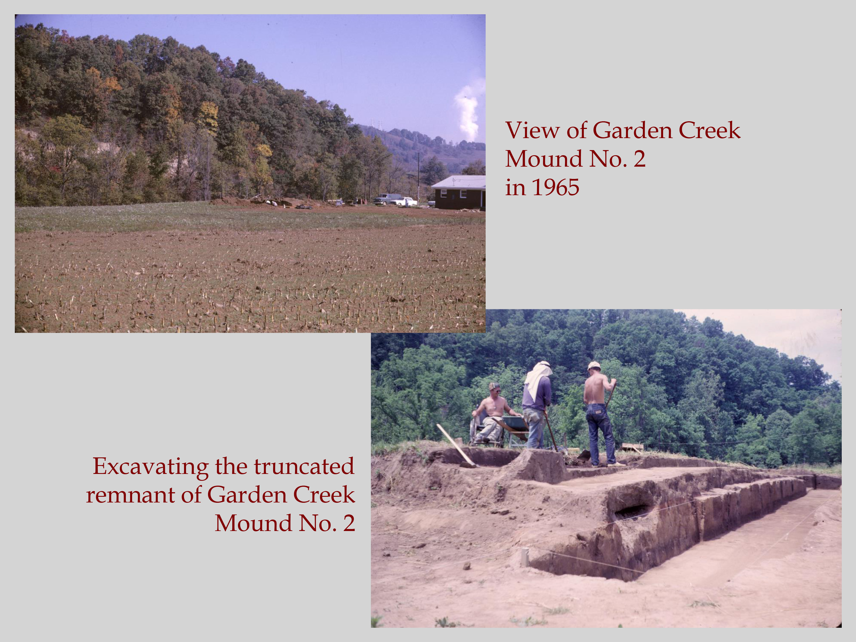
The first excavations at Garden Creek took place in the 1880s, when Mann S. Valentine and his sons hired A. J. Osborne to find Indian relics for their museum in Richmond, Virginia. The mound was revisited in the 1960s, when archaeologists realized the two mounds left were in danger of disappearing as a result of a housing development. UNC archaeologist Bennie Keel excavated the entirety of Mound #2 in the mid-1960s with funding from the National Science Foundation. The basis of the grant was the landowner’s decision to use the large “bump” on his property (Mound #2) for fill dirt to prepare an adjacent house lot for sale. About half the mound was destroyed before archaeologists arrived. Luckily, they were able to convince the owner of its archaeological significance and get his permission to excavate what was left. Based on ceramic chronology and a radiocarbon date from the top of the mound, Keel assigned it to the Middle Woodland Connestee phase. In 2011 and 2012, additional excavations were completed by Alice Wright of Appalachian State University, which focused on the off-mound area of the site. Her excavations combined shallow archaeological geophysics (called remote sensing) with targeted excavations based on the results. Using a gradiometer and ground penetrating radar, she identified pits, pit hearths, postholes, and other architectural evidence.
Research Questions
Mound #2 at Garden Creek was built by the Connestee phase people, who lived from about AD 200-600. Connestee sites are generally larger than earlier Woodland sites in the Appalachian Summit region, and people seem to occupy Connestee sites for longer periods of time. They are usually located in the floodplain of major streams. Sites may cover an area of several acres and have numerous features and structures. Small, temporary Connestee campsites are also found in a wide range of surrounding environmental zones. Radiocarbon dates from North Carolina sites indicate that the Connestee phase might extend into the Late Woodland period, even as late as AD 1000.
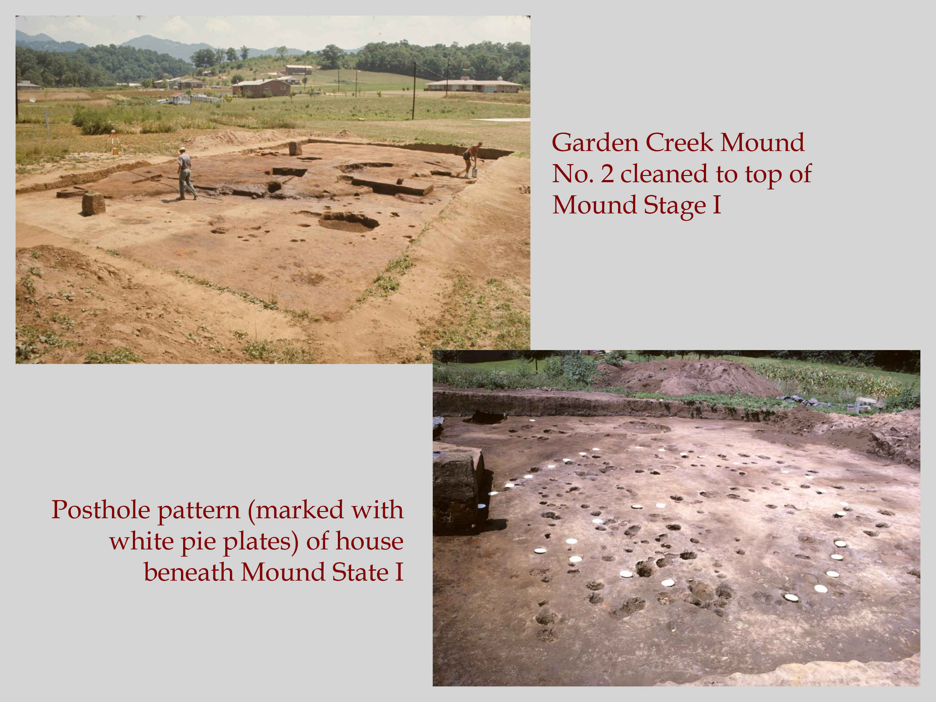
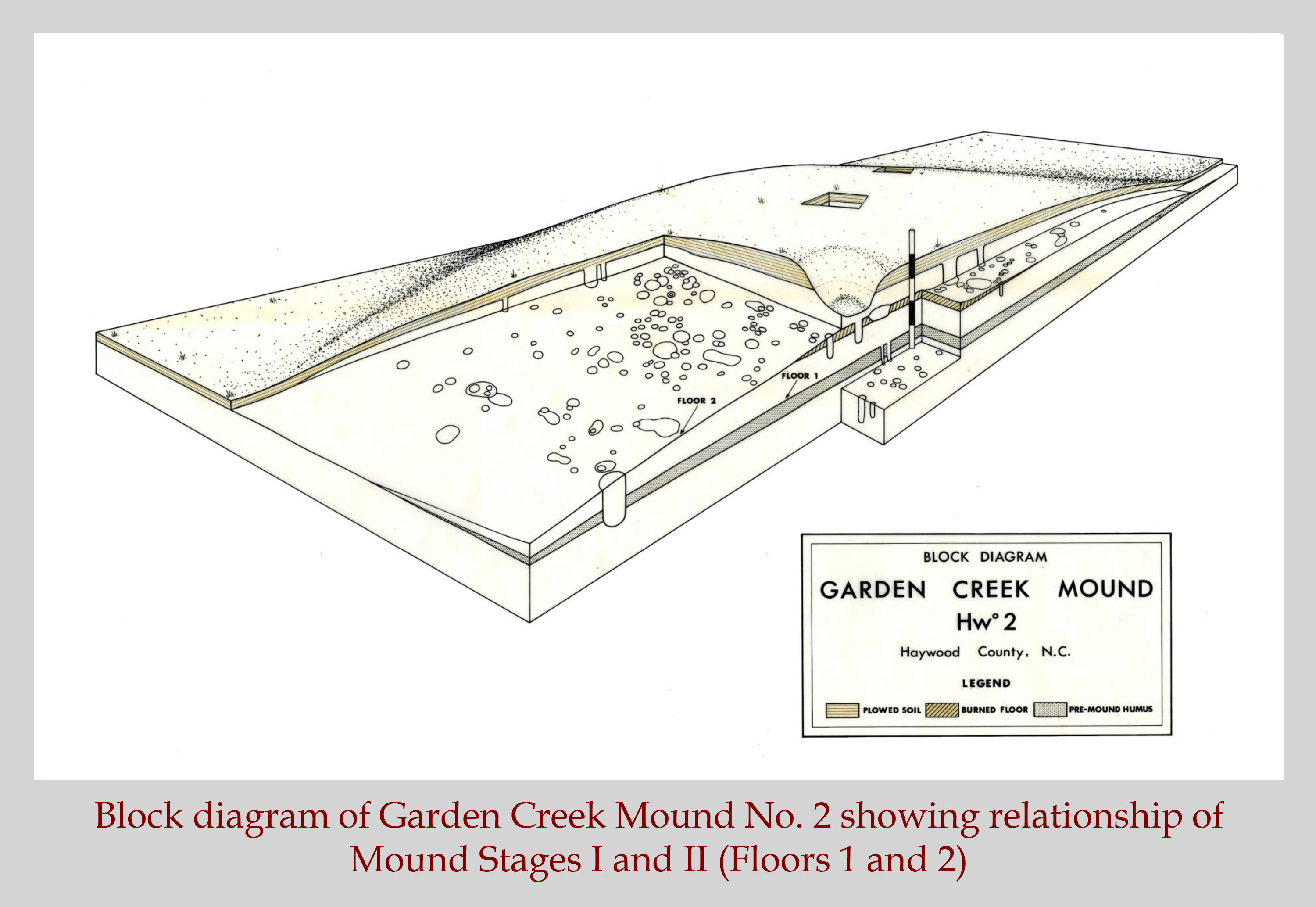
The Connestee phase Garden Creek Mound #2 was a small, earthen platform mound. The excavations undertaken by Bennie Keel found two soil layers beneath the plow zone that represented distinct, successive stages of mound construction. Both of these mound stages were built and used during the Connestee phase, and they were low platforms that served to elevate public buildings. Keel’s excavations also revealed that the mound was built on top of a midden (trash remains) that was left by the people who lived at the site before the mound was built. Artifacts found in the midden indicate that this earlier occupation also dated to the Connestee phase in the 2nd or 3rd centuries AD. At the base of this pre-mound midden were the remains of an almost square post-in-ground structure that measured 20-ft by 19.5-ft. When this initial structure was dismantled and the posts were removed, the resulting postholes were filled with clean, white sand, which made it easy for the archaeologists to identify.
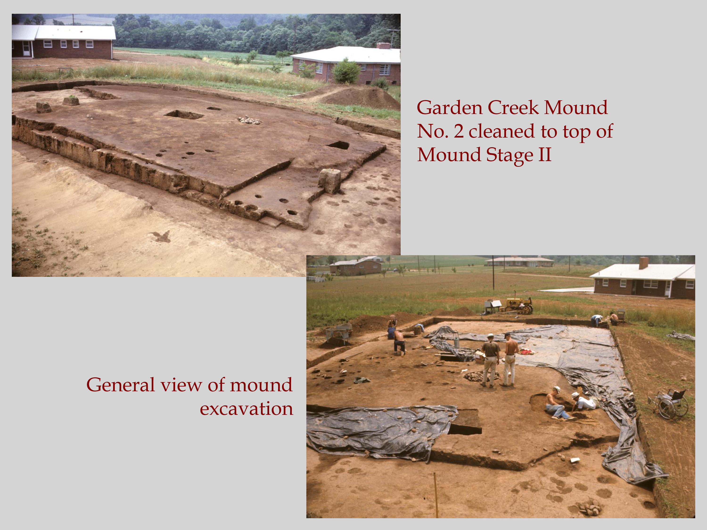
The first mound measured approximately 40-ft by 60-ft and was a little less than two feet high. A lot of activities happened on the top of this mound stage, including construction of a possible structure on the top of the mound that had a burned floor. This first stage was built shortly after the pre-mound midden was deposited. It was likely used for a maximum period of only 200 years, and more likely only 100 years. The second mound was 80-ft by 60-ft and is estimated to have been between 7 and 9 feet high. Plowing and bulldozing destroyed the summit of the mound, but if it was in use for a similar amount of time as the first mound summit, then it would have been in use primarily during the 4th century AD.
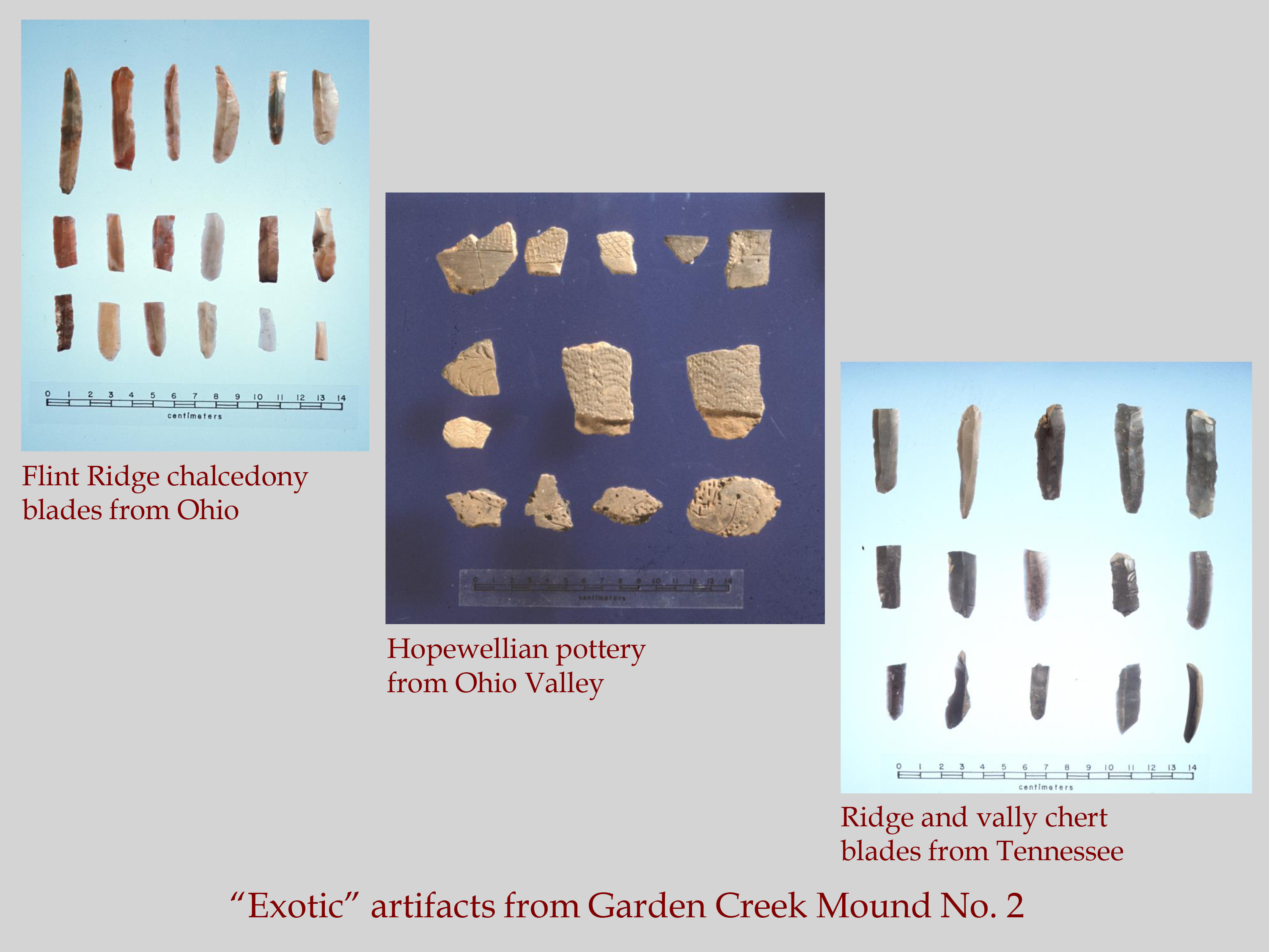
Within the mounds, of note were rock-filled hearths that contained ash, charcoal, burned bones, broken pottery, and other refuse. Architecturally, the mounds look similar to a Kolomoki pattern platform mound, with an associated ceramic assemblage that ties people to monumental and material practices more closely associated with people elsewhere in the Southeast. Also recovered during excavations were artifacts that were nonlocal, made of “exotic” materials or showing nonlocal artistic styles. These objects help to show the connections that the people living at Garden Creek had with other Middle Woodland groups living in eastern Tennessee and Ohio. Noteworthy pieces included clay figurines with human and animal forms, prismatic stone blades made from chert and chalcedony rock, copper sheets, beads, and a copper pin. Many of these probably originated in the Hopewell region of Ohio. Several potsherds were recovered that look like they were imported items from the Ohio Hopewell area and eastern Tennessee. This interaction between Hopewell and Connestee people might have happened as a result of the mica resources in the western North Carolina mountains. Travelers from the Ohio River Valley would have traded their exotic items for the raw mica materials they could not find in their native region. This hypothesis is supported by microwear analysis of Hopewell flint blades from Garden Creek by Larry Kimball (1992). He found that the blades were used for a variety of cutting tasks and at least two were used to cut soft stone like mica.
The spatial arrangement of postholes, pits, and hearths around the mound suggests that the area was subject to intermittent habitation and might even be related to seasonal gatherings of Middle Woodland groups. Wright’s project on the non-mound areas also identified small geometric enclosures, rectangular in shape with rounded corners. Enclosure 1 was the only one that was test through excavation. It consisted of a steep-sided ditch that had nearly flat walls and a flat bottom. The ditch was ultimately filled in with soil, at which point the outline of the enclosure was marked with posts in the middle of the ditch. When the posts were removed, the holes were filled primarily with river cobbles. Other notable fill material included high densities of cut sheet mica fragments and crystal quartz debitage (by-products of tool making). Both of these finds may be representative of Hopewell craft production. The mica scraps would have been thrown into the ditch at the same time it was being filled in which other soil, which suggests that cut mica production was associated with the enclosure itself. Based on carbon dates, the ditch filling, creation and destruction of posts, and filling of postholes lasted 130 years at most, and possibly lasted only about 80 years, beginning about AD 29 and ending by AD 106. Enclosure 1 appears to be most closely related to interaction with northerly Hopewell peoples, which suggests that there were more formal ritual ties between people in the Appalachian Summit and the Ohio Valley than we previously realized.
Sources
Keel, Bennie C.
1976 • Cherokee Archaeology: A Study of the Appalachian Summit. University of Tennessee Press, Knoxville.
Kimball, Larry R.
1992 • The Function of Hopewell Blades from the Southeast. Research Notes 12. Frank H. McClung Museum, University of Tennessee, Knoxville.
Ward, Trawick H., and R. P. Stephen Davis, Jr.
1999 • Time Before History: The Archaeology of North Carolina. University of North Carolina Press, Chapel Hill.
Wright, Alice P.
2014 • History, Monumentality, and Interaction in the Appalachian Summit Middle Woodland. American Antiquity 79(2):277-294.