
Early Campus Depictions
The University of North Carolina at Chapel Hill is the nation’s oldest public supported institution of higher learning. Chartered in 1789, the decision by the University’s trustees to place the campus at “New Hope Chapel hill” in southern Orange County was made in 1792 after local citizens there offered to donate 1,290 acres of land and £768 toward the endeavor. The cornerstone for the first building, East Building or Old East, was laid on October 12, 1793, and later the same day lots adjacent to the planned campus were sold at auction to establish a “Village at the University.”
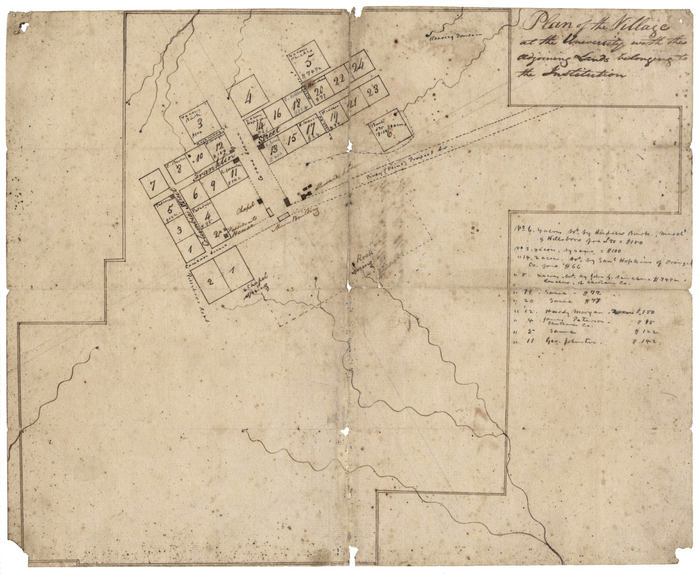
By February 1795, when the first students arrived to take classes, the campus was comprised of three buildings — East Building, Steward’s Hall, and the President’s House. Of these, only Old East remains. The campus grew very slowly during the nineteenth century, always struggling due to limited financial resources to meet the demands of an ever-growing student population. The map at top right, titled “Plan of the Village at the University with the adjoining Lands belonging to the Institution,” shows the University’s campus consisting of East Building or Old East (not labeled), Chapel (now Person Hall), President’s House, and the Steward’s Hall. Main Building (South Building) and Old West are depicted as open rectangles, indicating that they were under construction or planned, but not completed. Buildings also are shown at the corners of Lots 5, 11, 12, 13, and 14 (University Archives, Wilson Library, University of North Carolina at Chapel Hill).

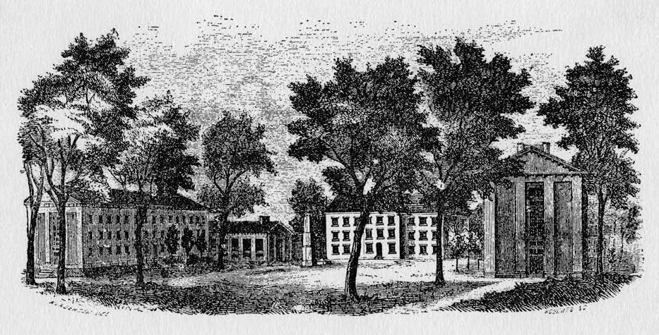
The earliest-known depiction of the general UNC campus was drawn in the mid-1840s and shows (from left to right) Gerrard Hall, South Building, and Smith Hall (now Playmakers). The view is looking northwest from the current site of Saunders Hall. It is thought to have been drawn shortly after 1844, when construction of Gerrard Hall was completed. Not shown are Old West, the President’s House, Steward’s Hall, or outbuildings such as privies that would have served the day-to-day needs of the university community (from Powell 1979:63).
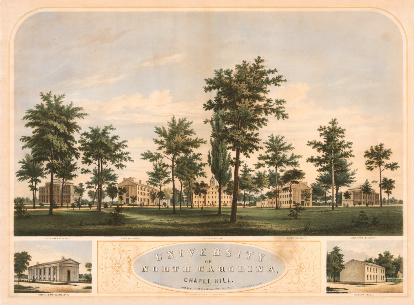
A second engraving of the UNC campus in 1855, by W. Roberts, shows (from left to right) Old East, Smith Hall, South Building, and Old West. The perspective of this view is looking southeast from the front (east end) of Person Hall.
In 1853 William D. Moseley, an early UNC alumnus, wrote to Professor Elisha Mitchell describing the composition of the University and Chapel Hill at the time of his graduation in 1818:
“…I know of no earthly pleasure which would afford me more heartfelt satisfaction than a short stay at that village; where I could again refresh my memory with a review of the places and things that still remain as mementos of days that are past; when the future was looked to with hopes, never to be realized. I would like to look into the room occupied by President Polk and myself; where we spent many pleasant hours in reading together the Latin & Greek authors; and in demonstrating the proportions in Conic Sectors; and being the first class that ever studied that branch of mathematics. Our room was in the So West corner of the 3rd story of what was then called the new college. I would like to to see the libraries, and to take a stroll through the village, beginning at Nunn’s and going eastwardly down the Main Street, first by Mrs. Mitchell’s on the right; Trice’s store on the left; then Major Henderson, then James Hogg’s immediately opposite; then the tavern occupied by Hilliard; then Tom Taylor’s store then, on the left, the Edmund Pitt’s dwelling, then Tom Taylor’s, then (East of the Raleigh road) Dr Caldwell’s residence, then, Mr Hooper’s; immediately opposite to the latter was Mrs. Puckett’s. This was then the principal street. South from Mrs. Nunn’s, was Wm Barbee’s, then the President’s house, occupied by yourself. Then So West was Pannell’s and Watson’s. These I believe were at that time the houses composing the village; with two college buildings; and Person Hall, Chapel.” (University of North Carolina Papers (#40005), University Archives, University of North Carolina at Chapel Hill)
By the 1840s, the campus consisted of six buildings. Old East, South Building, and Old West provided classrooms and also served as dormitories; Person Hall and Gerrard Hall were built as chapels; and Smith Hall (now Playmakers) housed the University’s library. The residence built in the 1790s for the president instead was occupied for many years by Professor Elisha Mitchell, while President Joseph Caldwell (1817–1835) and President David L. Swain (1835–1868) occupied a private residence, built by Caldwell and known as the Second President’s House, on East Franklin Street. During the years leading up to the Civil War only two additional buildings—New East and New West—were constructed, despite a burgeoning university population that grew from an average enrollment of 160 students and six professors in the 1840s to more than 450 students and ten professors by 1860.
A view of the campus at about the start of the Civil War and looking south from McCorkle Place is captured in a chromolithograph made by E. Valois & Rau. It shows the addition of New East (far left) and New West (far right).

While the University remained open throughout the Civil War, enrollment sharply declined and only a dozen students were enrolled by war’s end. Reconstruction-era politics ultimately caused the University to shut its doors in early 1871. After reopening in 1875, the student body grew slowly but steadily, and the University added a few new buildings to meet their needs, including the first Memorial Hall for commencement and other large gatherings and a gymnasium. Despite these additions, the UNC campus by the end of the nineteenth century remained quite small, consisting of less than a dozen buildings along Cameron Avenue, and much of the modern campus area was still either University-owned woodlands or privately-owned town lots supporting residences and commercial establishments.
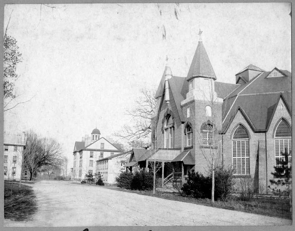
The only known depiction of the university village during the early post-Reconstruction era (c. 1875-1885) is a map drawn more than a half-century later by H. D. Carter. This 1934 plan of Chapel Hill shows the UNC campus centered on Cameron Avenue and the extent of the town’s residential and commercial development (North Carolina Collection). Photographs of the campus in the late 1800s are rare, and the few that exist give a rare glimpse of a university landscape that is both familiar and unfamiliar to the modern visitor. At right is a photographic view of Cameron Avenue sometime between 1885 and 1900, looking east toward the campus center. Old Memorial Hall, Gerrard Hall, South Building, and the northeast corner of Smith Hall are visible to the right, and the south ends of Old West and Old East can be seen to the left. Cameron Avenue, the main street through campus, is a dirt road that would not be paved until 1927.
Contributor
R. P. Stephen Davis, Jr. (Research Laboratories of Archaeology, University of North Carolina, Chapel Hill)
*Images courtesy of the North Carolina Collection, University of North Carolina, Chapel Hill.
Sources
Davis, R. P. Stephen, Jr.
2015 • The Hidden Campus: Archaeological Glimpses of UNC in the Nineteenth Century. Gladys Hall Coates University History Lecture, Wilson Library, University of North Carolina, Chapel Hill, April 14, 2015.
Powell, William S.
1979 • The First State University: A Pictorial History of the University of North Carolina. University of North Carolina Press, Chapel Hill.