
Otter Creek Wreck (Pamlico County)
The Otter Creek wreck represents a vessel used in commerce during the Federal Period (1788-1800). Located at the confluence of the Otter and Green Creeks near the main channel of the lower Neuse River as it opens out into the Pamlico Sound, the wreck is situated 150 ft. from land in 4 ft. of water. Excavations were supervised by the NC Underwater Archaeology Branch (UAB) and conducted by an East Carolina University graduate student with assistance from the international program Operation Raleigh (now Raleigh International). This round-the-world expedition was established by Britain’s Prince Charles to develop youth leadership skills through projects that provided scientific and community aid. Twenty participants, aged 17 to 24, and four adult supervisors from Operation Raleigh provided diving and tactical support during the investigation. The results of this work provide evidence for a relatively large, two-masted vessel. Based on the ship’s projected size and its location near a major shipping channel, the remains are probably from a merchant sailing ship that was abandoned in the creek where it would not hinder navigation and could later be salvaged.
History of Excavation
In December 1986, staff of the Underwater Archaeology Branch (UAB) examined the waters from the town of Oriental where a marina and channel dredging were proposed to be built. Using a , an abnormal reading was located and then probed from the survey boat with a pole. Based on the probing, archaeologists determined a solid structure lay within the creek’s soft bottom. Further investigation revealed a line of rotten wooden ribs from a rather large vessel with its bow pulled up into the shallows. A follow-up visit by UAB staff confirmed initial findings and called for additional investigation before any construction activities.
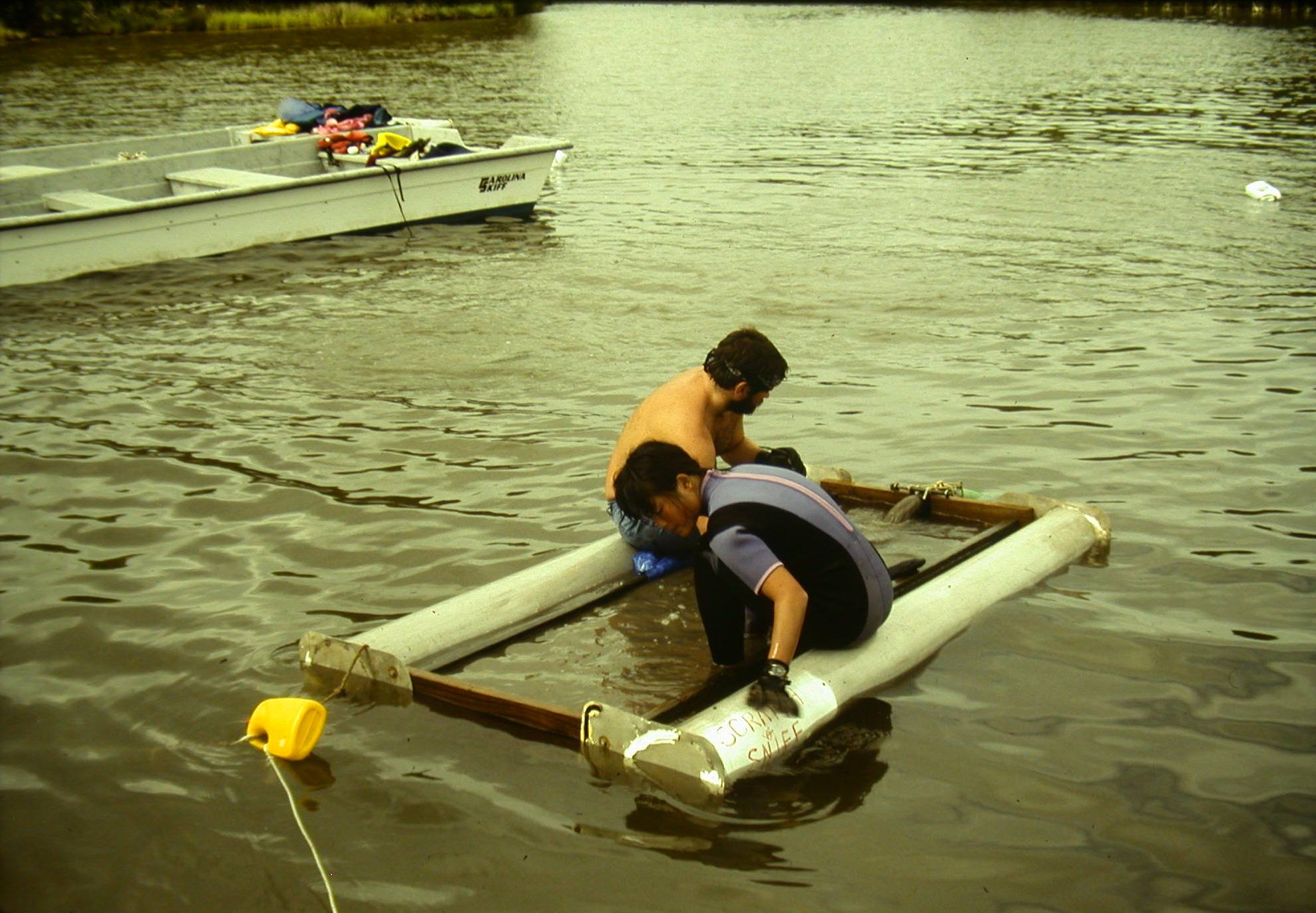
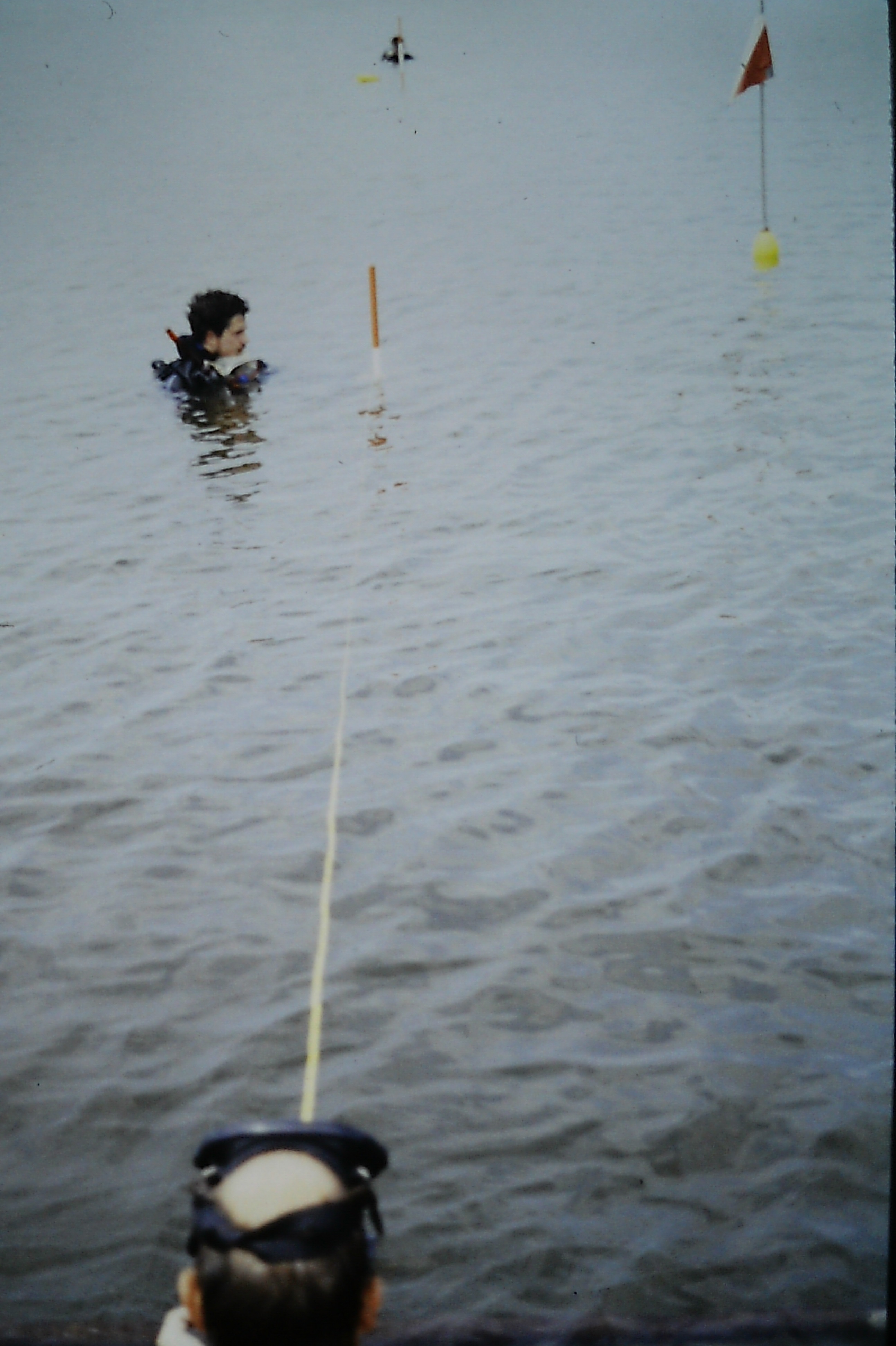
In August of 1988, a large crew of UAB and ECU students and supervisors supported by the contingent from Operation Raleigh set up camp on a nearby shore for a two-week investigation of the Otter Creek shipwreck. A large, gas-powered fire pump was used to run two 3 in. dredges to clear mud in order to determine the locations of the ends of the vessel. Later the dredges were used in conjunction with a floating screen to excavate the hull’s interior. The vessel’s bow lay in only a few feet of water with little mud to clear off; however, the stern sloped down into deeper water where it was covered with 18 inches of soft mud and lots of organic materials from leaves to arm-sized limbs. Once the ends were found a cable was stretched from stem to stern and served as a baseline for excavations into the lower ship’s hull.
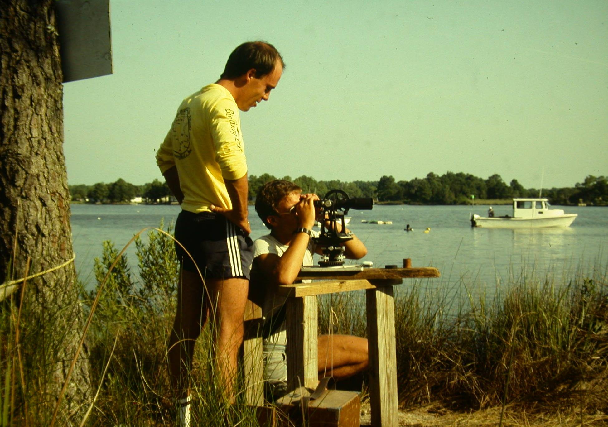
To provide horizontal control and positioning a measuring tape was attached to the cable and findings were recorded in relation to this makeshift baseline. In addition, two transit positions were established on the shoreline. The two transit positions plus the shipwreck provided three points from which to triangulate the shipwreck’s position on the earth’s surface. Archaeologists were also able to use transit stations to record site elevations. The initial excavation trench was placed at the center of the wreck and extended crosswise to expose the vessel’s and . From there a long trench was extended in either direction down the center to the stem and stern. Finally, two excavations were placed on the outside of the vessel remains down its port side – one in the very back of the ship in an attempt to locate the rudder and the other at the middle of the ship to document the keel and outer hull assembly. Throughout the excavation loose timbers were brought up for documentation and then returned to the site for reburial. A handful of diagnostic artifacts were retained for further analysis.
Research Questions
Since at the time archaeologists had documented only a few wooden sailing vessels sunk under the waters of North Carolina, research questions centered on the basics at Otter Creek. What was its approximate age? How was it constructed and what materials were used? What was its capacity, use, and means of propulsion? How did it end up at its present location and why? Historical research gives us some clues regarding the last question. The area at the mouth of the Neuse River saw little development or use until the town of Oriental was incorporated in 1899; the rural population in the area was sparse and primarily engaged in subsistence farming and fishing. However, forty miles upriver from the Otter Creek wreck is New Bern. Use of the Neuse River would have been related to the development and commerce of New Bern, which for a time in the late eighteenth century served as the capital of North Carolina. More specifically, the wreck may be associated with Famifold Green and his descendants, who were the largest property owners and played a key role in the development of the lower Neuse River region. Maps of the vessel area do not show a landing in that location, but the area did provide a relatively safe harbor off the main river channel for ships sailing in the vicinity. It is likely that the Otter Creek vessel, at a time of duress after crossing the Pamlico Sound, sought out the protection of the creek and was subsequently abandoned after crew and cargo were removed. Answers to the many other questions rely on what archaeologists were able to dig up during their two week investigation.
Findings
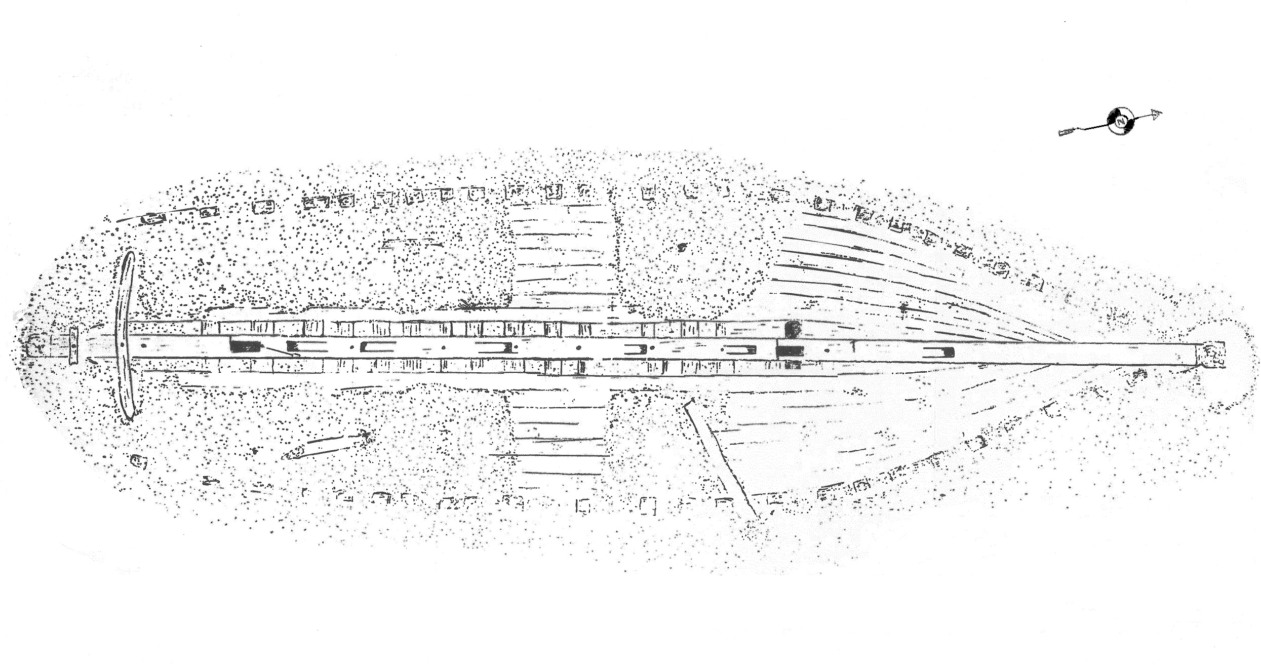
Excavations conducted on the Otter Creek wreck revealed that approximately 20 percent of the original hull was in a well-preserved condition below the mud-line. The wreck represents a ship originally measuring 58 ft. in length with a of 16 ft., a of 9 ft. and approximately 100 tons . Constructed mostly of white oak, the presence of double frames suggest it was built for ocean-going service. The outer pine hull sheathing indicates the ship sailed in southern waters. Furthermore, methods of construction indicate the vessel was probably built during the last half of the eighteenth century. Based on the fact that the keelson butted against the sternpost, we know the vessel postdates 1750. Two other aspects of the ship show construction methods that were practiced before the beginning of the nineteenth century. These were the use of wooden rather than iron knees and bolting every other floor to the keel.
The use of hickory for tells us that the ship was most likely built in North America, but it is uncertain exactly where. The construction techniques used in the Otter Creek vessel were similar to those used in the Chesapeake Bay region, however, several features make it unique. First, its two were placed directly over the keelson , a feature which has only been found on a much larger British ship built in 1818. Another unique feature was the keelson scarfs themselves, which were cut vertical at the forward end and horizontally at the two scarfs towards the rear of the ship. Finally, the Otter Creek vessel was fitted with a series of pillars that supported its deck beams. This was normally only employed on larger ships that carried heavy deck loads. Perhaps the pillars were meant to reinforce a sagging deck to extend the life of the ship.
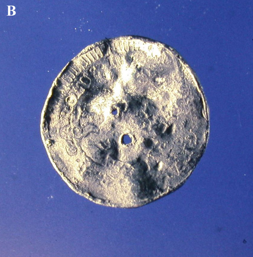
Non-structural artifacts were scarce, as if the ship had been abandoned in shallow water and cleaned out. Glass and pottery artifacts generally support a late eighteenth and early nineteenth century period of use. and were plentiful and may have been part of the cargo. Analysis of faunal and botanical specimens showed a wide variety of domestic food resources, including coconut shells that point to the ship’s possible trade with a Caribbean port. The most unusual artifact was a curious metal button impressed with a Spanish coin containing the bust of Carolus (Charles) III. This type of coin was minted after 1772, providing a date after which (terminus post quem) the Otter Creek wreck was in service.
The exploration of the Otter Creek provided researchers and Operation Raleigh participants an interesting focus for their August 1988 expedition. The results of their study also helped snuff a local rumor that went viral, in a pre-social media way. Among the pieces collected when the ship was first found in 1986 was a rudder hinge that had a reflective glint. A couple of the locals who saw it joked that it might be made of silver and thus buried treasure, since nearby a venerable old tree once stood, known to locals as Teach’s Oak. According to legend, it was here that Blackbeard set up camp and from high up in the tree he kept watch on local shipping activities.
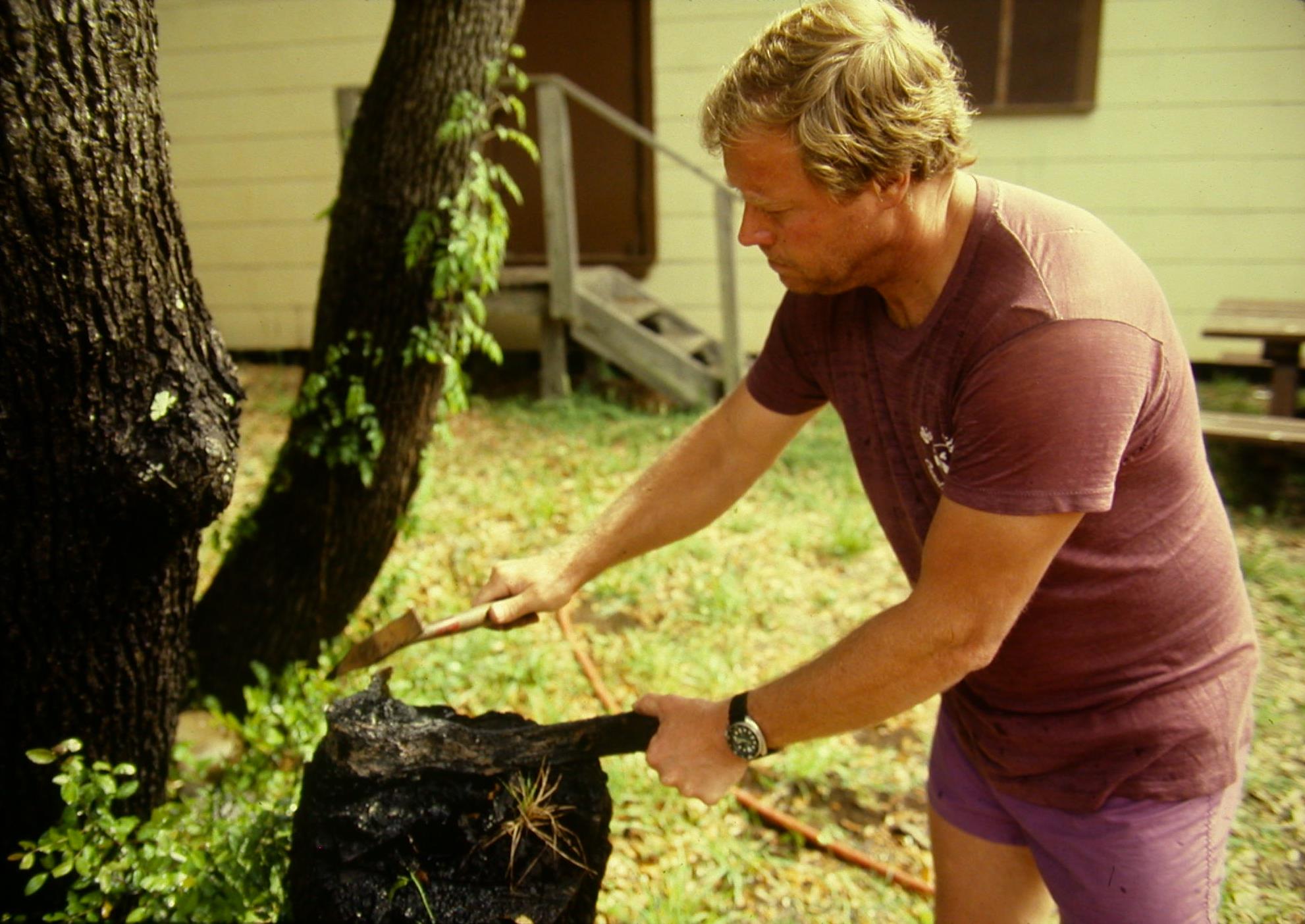
In the months that followed, gossip surrounding the old ship and possible booty began to circulate within the community; this was picked up by the local newspaper and in turn, the Washington Post. Consequently, UAB staff ended up providing radio interviews to stations as far away as Vancouver, Canada. While the attention was appreciated and it demonstrated the power of pirates, analysis confirmed the rudder hinge was crafted of very practical wrought iron. The ship’s construction and associated artifacts also provided strong evidence that the Otter Creek vessel sailed well after Blackbeard and crew pirates menaced the Atlantic seaboard.
Contributor
Mark U. Wilde-Ramsing (North Carolina Underwater Archaeology Branch (Ret.))
*Images courtesy of the North Carolina Underwater Archaeology Branch, Department of Natural and Cultural Resources
Sources
Jackson, Claude V., III
1991 • Historical and Archaeological Investigations of a Federal Period shipwreck near Oriental, North Carolina. Master’s Thesis, East Carolina University, Greenville.
Wilde-Ramsing, Mark
1986 • Otter Creek magnetometer and site assessment, North Carolina. Manuscript on file, Underwater Archaeology Branch, Kure Beach, NC.
1987 • Examination of the Otter Creek wreck, Manuscript on file, Underwater Archaeology Branch, Kure Beach, NC.