
Fort Caswell (Brunswick County)
On the easternmost point of Oak Island at the mouth of the Cape Fear River lies a ruin rich in local and national history and archaeological significance. Fort Caswell was built in this location to guard the entrance to the Southpoint harbor from potential threats from the Atlantic Ocean. It has stood for nearly two centuries as a reminder of the strategic importance of the Cape Fear River and the port of Wilmington in North Carolina. Named for Richard Caswell, the state’s first post Revolutionary War governor, Fort Caswell is one of 48 fortifications that were built as part of the Third System forts to improve Eastern coastline defenses after the War of 1812.
Although much of the original brick and mortar fort survives today, important architectural features and the fort’s larger history have, until recently, been hidden beneath the sand. The William Peace University Archaeological Field Schools, co directed by Thomas Beaman (Associate Professor of Anthropology, Wake Technical Community College) and Dr. Vincent Melomo (Associate Professor of Anthropology, William Peace University), conducted the first archaeological investigations at Fort Caswell during the summers of 2013 and 2015.
History of the Fort
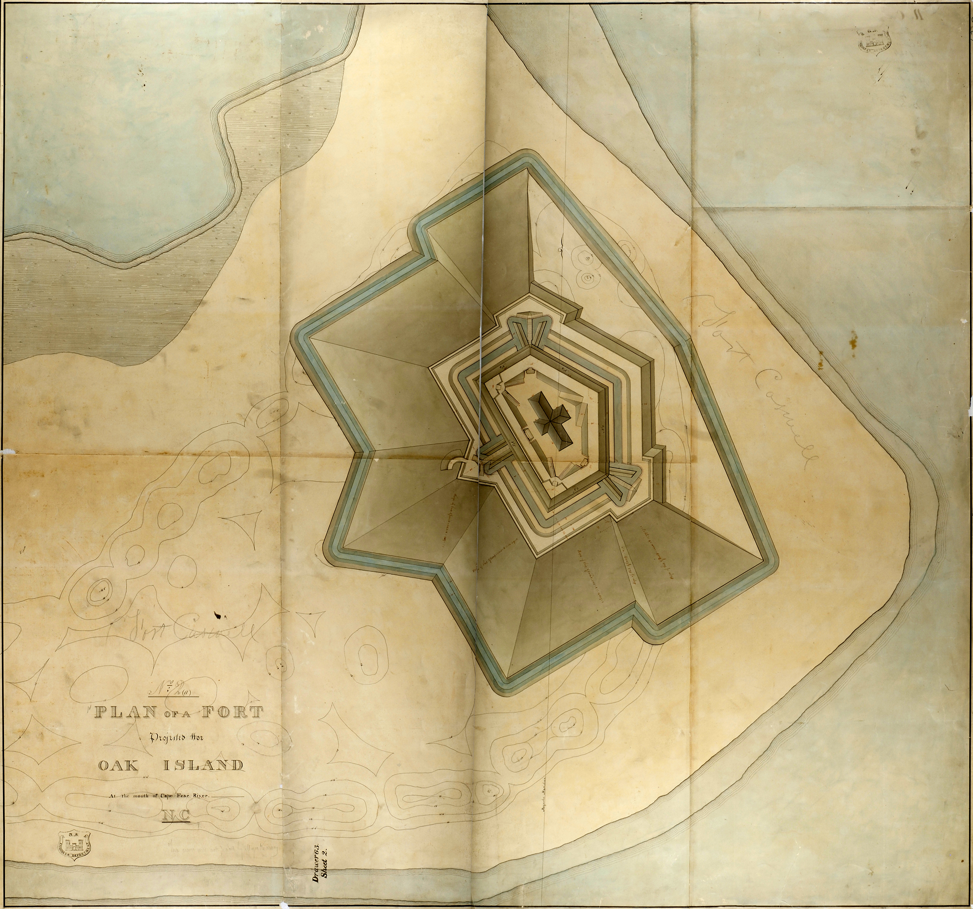
Based on concerns from the War of 1812, Congress appropriated over $800,000 in 1816 for the construction of a new seacoast defensive system. As a result of the relatively peaceful conditions that followed the War of 1812, Third System forts were known for a new level of standardization in their design and planning. The overall plan included large structures with many guns concentrated in tall, thick masonry walls, combined with layers of low protected-masonry walls. Most forts also had two tiers of cannons, distinguishing them from First and Second System forts which usually only had one tier. The construction of Fort Caswell began in 1826 and finished in 1837. It was originally designed as a five-sided truncated hexagon, similar to many other third system forts, but also had its own unique features. These included a four-foot thick masonry wall, a cross-shaped “citadel” used as soldiers barracks in the center of the fort, three pairs of rifle gallery extensions (allowing soldiers to better defend entrances), and wet and dry moats. All of these design features worked to help soldiers defend the fort from attacks by both land and sea.
Following Fort Caswell’s initial construction, there were also many disturbances and changes made to the fort. Changes included significant damage to the fort during the Civil War and the addition of new batteries during the 1898 Spanish American War. Alterations to the site continued throughout the 20th century as the fort was used on and off for civilian and military purposes, particularly during World War I when Fort Caswell served as one of two primary training centers for soldiers before their departure for Europe. Since 1949 the North Carolina Baptist Assembly has operated the site as a religious retreat and conference center and has been an outstanding steward in the preservation of this important historical resource.
The primary reason behind archaeological investigations was to contribute to Fort Caswell’s National Register of Historic Places nomination, as well as to provide comparative data for future investigations of similar fortifications and of Civil War and World War I era sites. Based on discussions with Richard Holbrook, Director of the Fort Caswell Coastal Retreat and Conference Center, as well as with local and national experts on the military history of the Cape Fear, a set of research questions was created in 2013 that guided both seasons of excavation. Since no archaeological investigations had been previously conducted at Fort Caswell, the research questions focused on the archaeological integrity of the site and better understanding some of the unique architectural features of the fort.
Archaeological Investigations
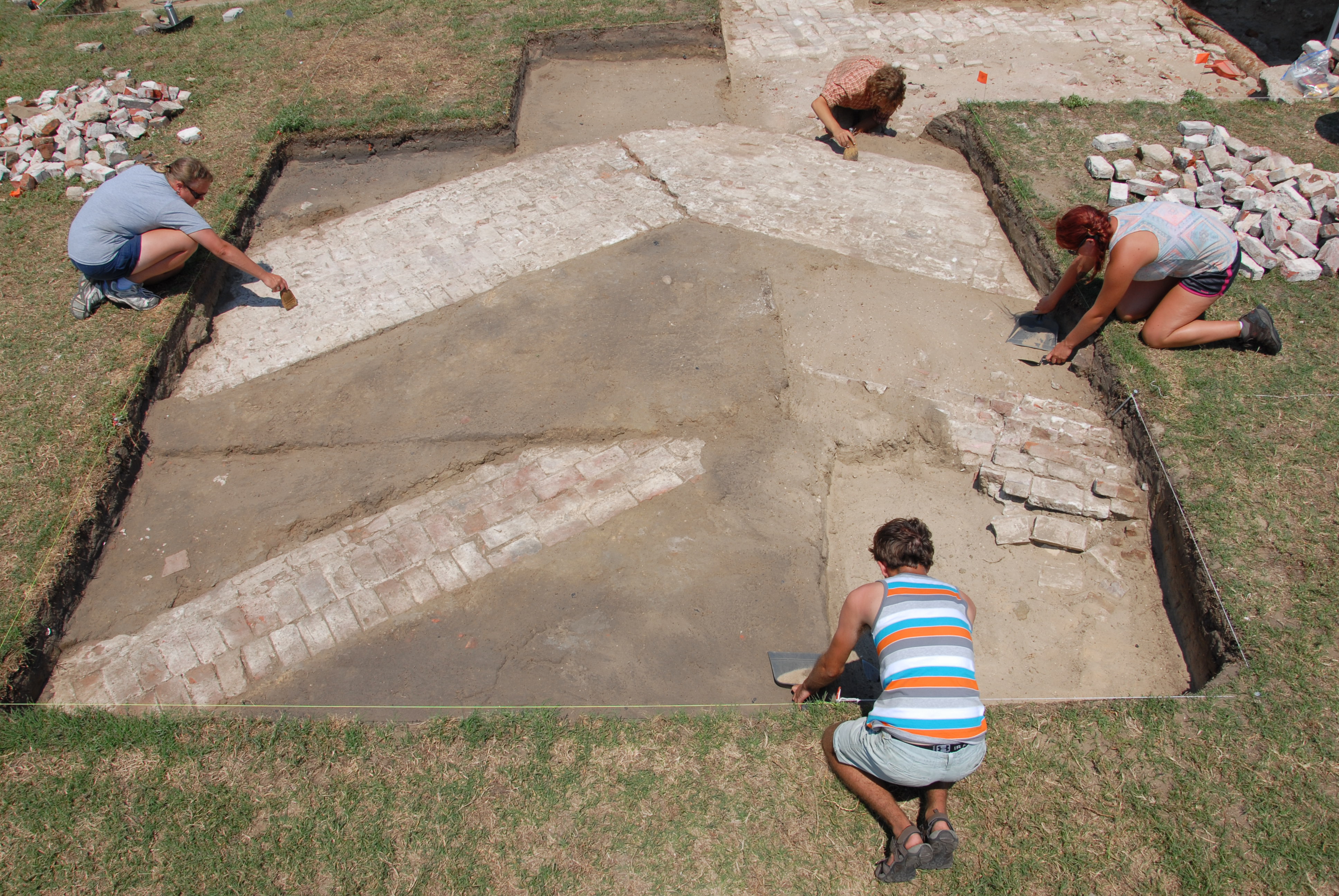
Over the course of the 2013 and 2015 field seasons, a total of 50 10 ft. x 10 ft. units were excavated. A 30 foot trench was also opened in order to expose one of the surviving caponiers (rifle gallery extensions). Although the artifacts from the field schools are still being processed and inventoried, the results clearly documented the integrity of the archaeological resources at Fort Caswell, specifically in relation to several key architectural features of the original construction and use during the Civil War era. When evaluating National Register nominations, the existence of intact archaeological remains (archaeological integrity) is incredibly important as a method for documenting the potential for new information that is important to prehistory or history. In this case, showing that the archaeological deposits at Fort Caswell are intact, especially deposits related to its construction and use, therefore provides evidence that the Fort is worthy of preservation on a national level.
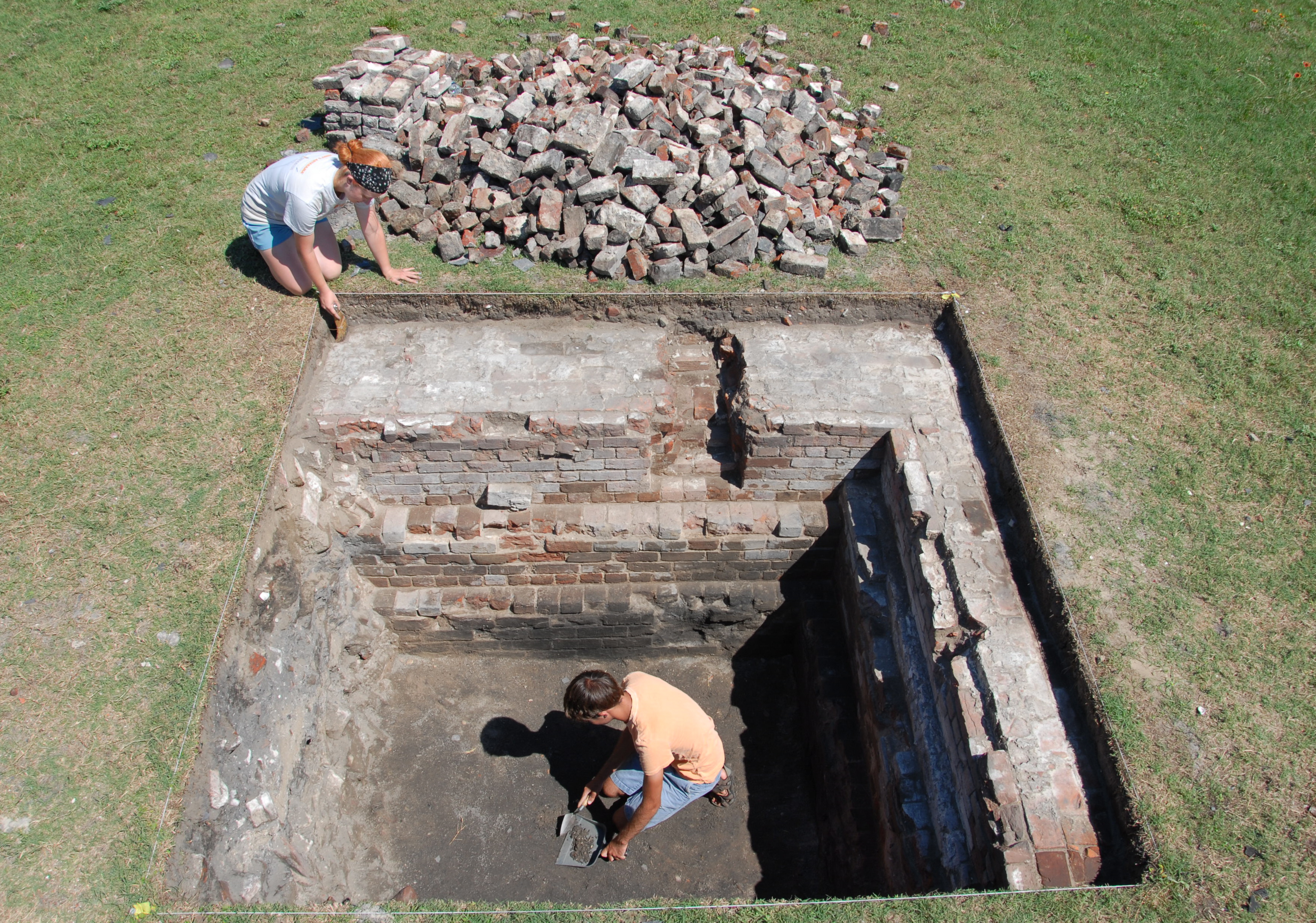
Based on the primary research questions, the initial archaeological goal was to relocate, define, and document the cross shaped citadel in the interior of the fort. Described as a two story brick structure measuring 100 ft. by 40 ft., this structure served as the barracks for both officers and enlisted men during the occupation of the fort. The citadel was partially burned when Confederate militia from Southport abandoned the fort in January of 1865, but an undated photograph from the second half of the 19th century indicates that the citadel’s shell stood empty for a number of years. When or how the structure disappeared is not well documented.
Over the two field seasons we were able to successfully show that most of the walls of the citadel are still intact beneath the current ground surface; only the southernmost portion of the citadel was impacted by later construction events. In addition to documenting the location and condition of the exterior walls of the citadel, the investigations revealed other architectural features of the citadel and evidence of its destruction. In the northern wing of the citadel the remains of two massive chimneys and fireplaces were uncovered,] and several of the entryways to the central foyer were also excavated. In all of the units opened in the interior of the citadel, brick and mortar rubble were encountered, with high amounts of slate roofing tiles in the upper levels. Past the top of the walls as much as five feet of brick and mortar rubble accumulated, mixed with pockets of charred wood and ash. Based on historic documents, we know that Confederates burned the citadel after the fall of Fort Fisher in Wilmington. The charred wood, ash, and roofing tiles provide the physical evidence to corroborate what was written down historically.
The second research goal in 2013 was to find the missing portion of the eastern fort wall and the fifth corner of the fort. Attempts to locate the wall were slowed by the presence of numerous features likely tied to the construction of the later batteries and the continued use of the fort in various capacities through the 20th century. However, by the close of the 2013 season we were able to uncover both the inner and outer section of the missing northeast wall and its interior rifle gallery. Although the remains of the wall were likely removed during late 19th-century improvements to the fort, the excavations revealed a large crack at the fifth corner of the fort, damage that likely occurred due to the explosion of a magazine (a building where powder and other explosives are kept) when the Confederates retreated.

During the 2015 field season another of the initial research goals was revisited: to archaeologically define and document the wet and dry moats that surrounded the fort. To uncover the moats, a series of units were opened extending out from the east and west walls of the fort. The units along the east wall of the fort uncovered pipes, conduits, and a roadbed made of reused brick and oyster shell. These features probably relate to the use of the fort during the late 19th and early 20th centuries and were left in place.
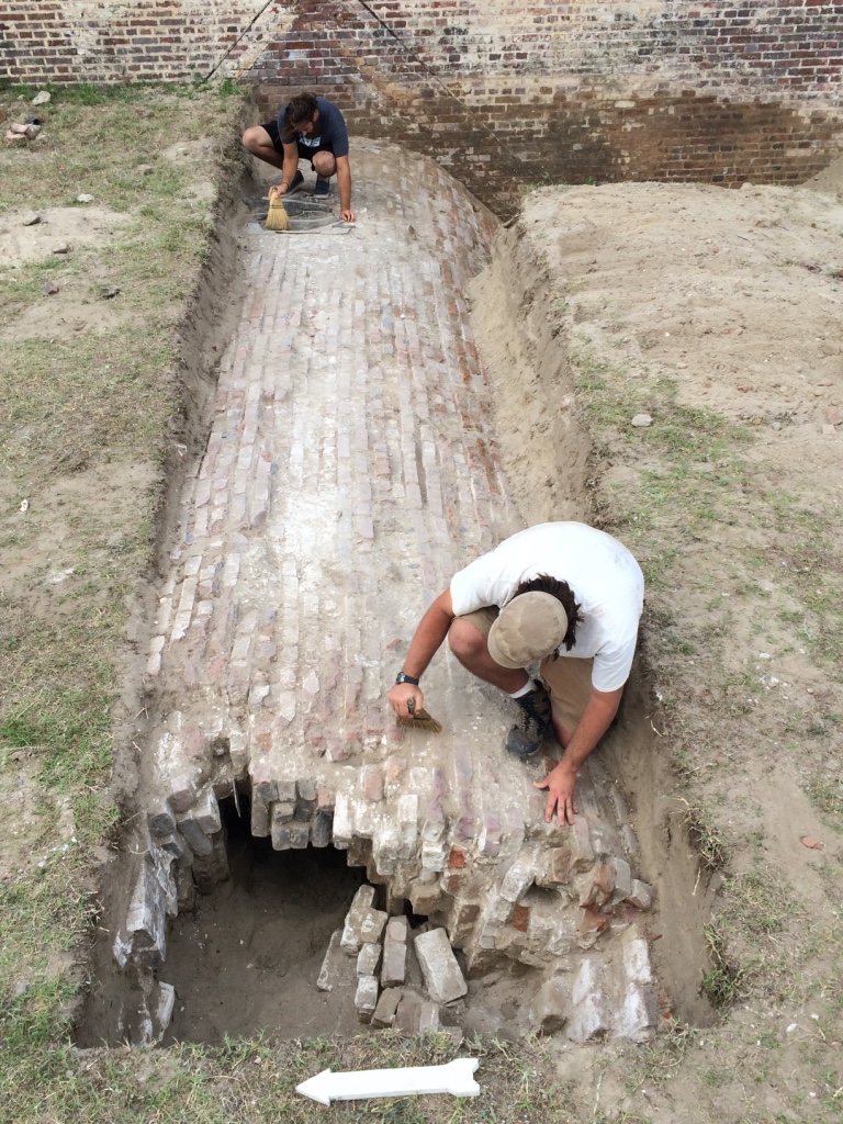
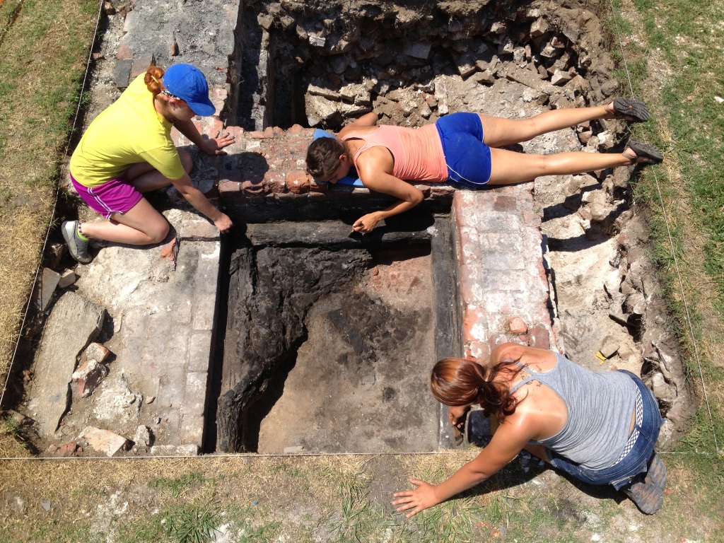
During the third week of the field school the brick and mortar walls lining the wet moat were found roughly six feet below the surface in the units along the exterior west wall of the fort. Just to the north of the west moat area, excavations also uncovered one of the four remaining caponiers. The structural details of the intact caponier were documented, including specific 19th-century modifications that were also recorded in the historic literature.
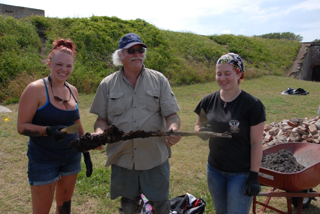
In addition to documenting these key architectural features, we hoped our archaeological work would help tell the stories of the soldiers who occupied Fort Caswell. Although further analysis of the recovered materials may yet be illuminating, we unfortunately found very few artifacts outside of architectural materials. However, some of the most notable finds included the complete remains of a Civil War era .54 caliber Austrian Lorenz rifle excavated in 2013 and one painted clay Civil War era marble, recovered in 2015.
Since the site had never been previously investigated, the goals and methods of the archaeology were modest, but the discoveries turned out to be significant. Over the eight weeks of WPU’s 2013 and 2015 field schools, we can say that nearly all of the research goals were successfully met. Most notably, the field schools documented the presence of intact subsurface remains of the citadel, located the missing eastern wall of the original fort, and uncovered the remains of the moat walls. While the conclusions that can otherwise be drawn from this research are currently limited, the most important accomplishment was in helping the site gain its place on the National Register of Historic Places in 2014, and in establishing the potential for future research to be conducted at this important historic site.
Contributors
Vincent Melomo (William Peace University)
Thomas Beaman (Wake Technical Community College)