
Lower Saratown (Woodland)
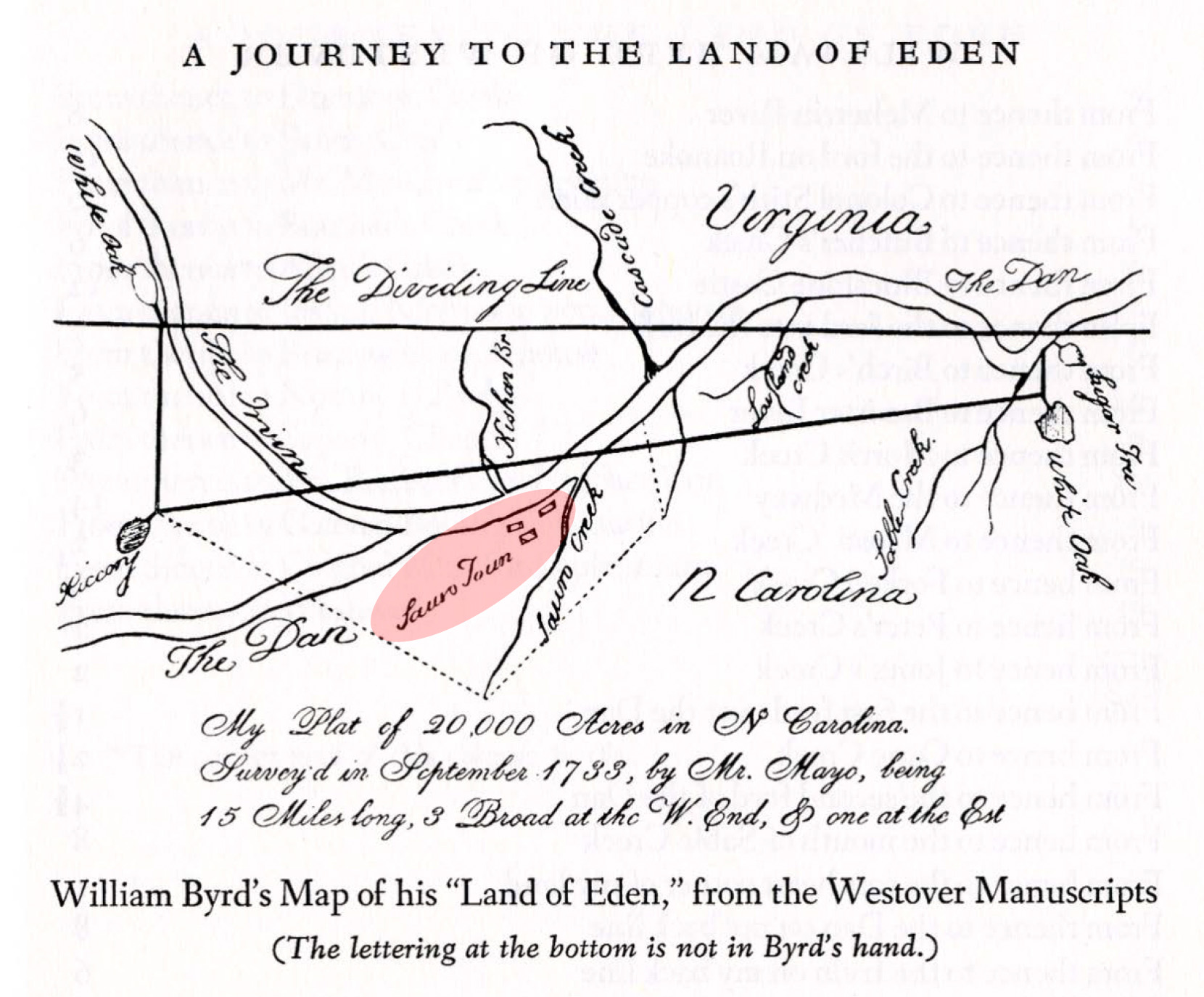
Lower Saratown (31RK1) is an archaeological site located along the Dan River in Rockingham County, less than a mile east of Eden. It contains evidence of two Woodland villages—one occupied during the late precontact Dan River phase (A.D. 1000-1450) and another that was occupied by the Sara, or Saura, Indians during the 1600s. The Sara village site is shown as “Sauro Town” on an early 18th century map of a 20,000-acre estate that Virginian William Byrd II received for his 1728 survey of the Virginia-North Carolina boundary. In describing the site and its prior occupants during a journey to the property five years later, Byrd remarked: “[t]hen on a sudden the scene changed, and we were surprised with an opening of large extent where the Sauro Indians once lived, who had been a considerable nation. But the frequent inroads of the Senecas annoyed them incessantly and obliged them to remove from this fine situation about thirty years ago. They then retired more southerly as far as Pee Dee River and incorporated with the Keyauwees, where a remnant of them is still surviving” (in A Journey to the Land of Eden, by William Byrd II, 1733). The Lower Saratown site, together with the Upper Saratown, Hairston, and William Kluttz sites in Stokes County, document the Sara occupation of the Dan River valley during the 17th and early 18th centuries.
History of Excavations
The first excavations at Lower Saratown were undertaken sometime before 1936 by Reverend Douglas Rights, a Moravian minister from Winston-Salem, North Carolina. Rights was contacted by Joffre Coe about the locations of historic Siouan towns and provided information about several sites, including Lower Saratown. Based on this communication, Coe obtained funds from the Indiana Historical Society in 1938 and excavated a 550 sq. ft. area in what was thought to have been the historic Sara village. Despite the fact that the excavations did not reveal any historic material, the site kept its reputation as historic Lower Saratown. We now know that the artifacts Coe found, including numerous fragments of net-impressed jars decorated with incisions and punctations, are associated with the Late Woodland Dan River phase and date several centuries before the Sara village mapped by Byrd.

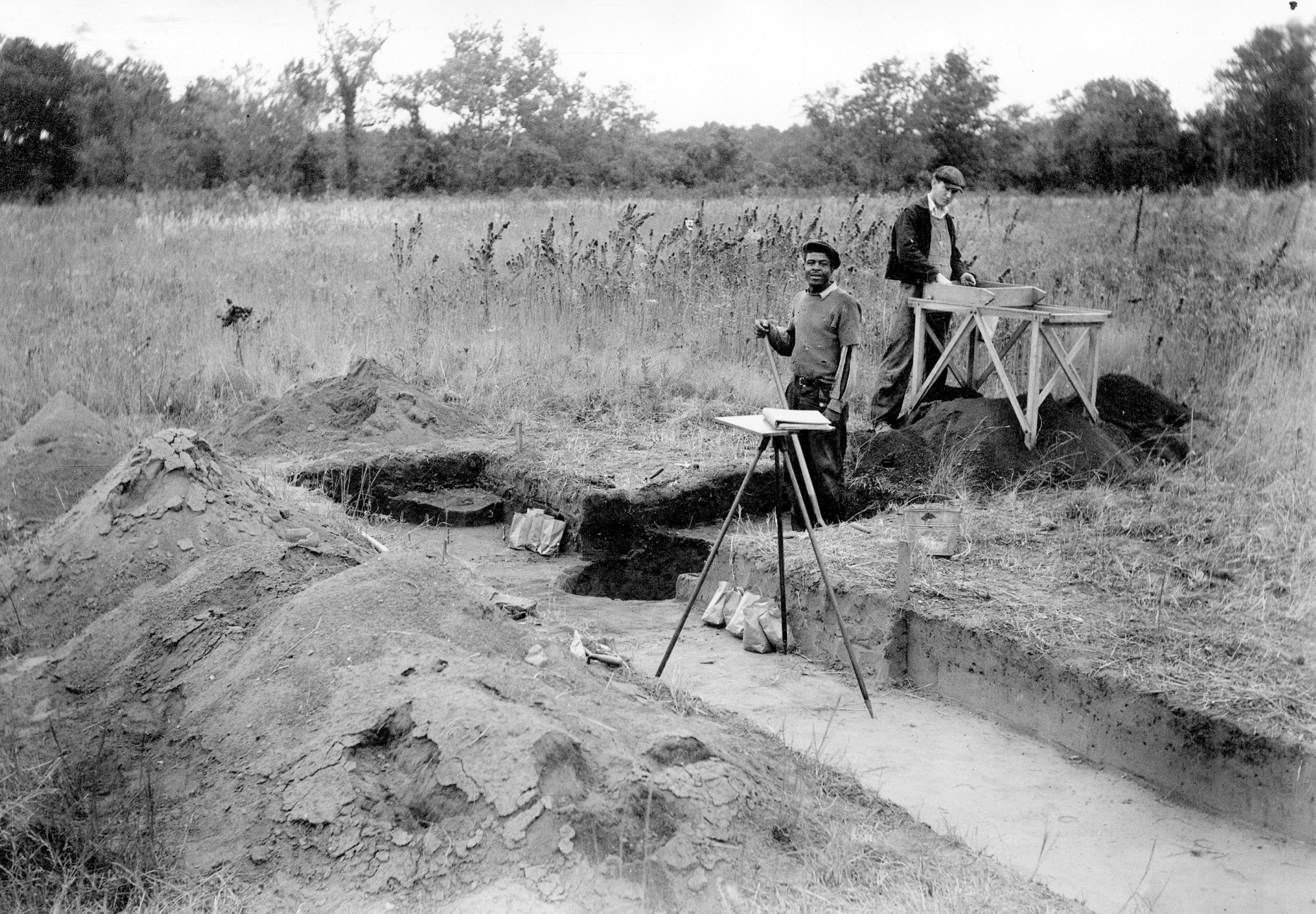
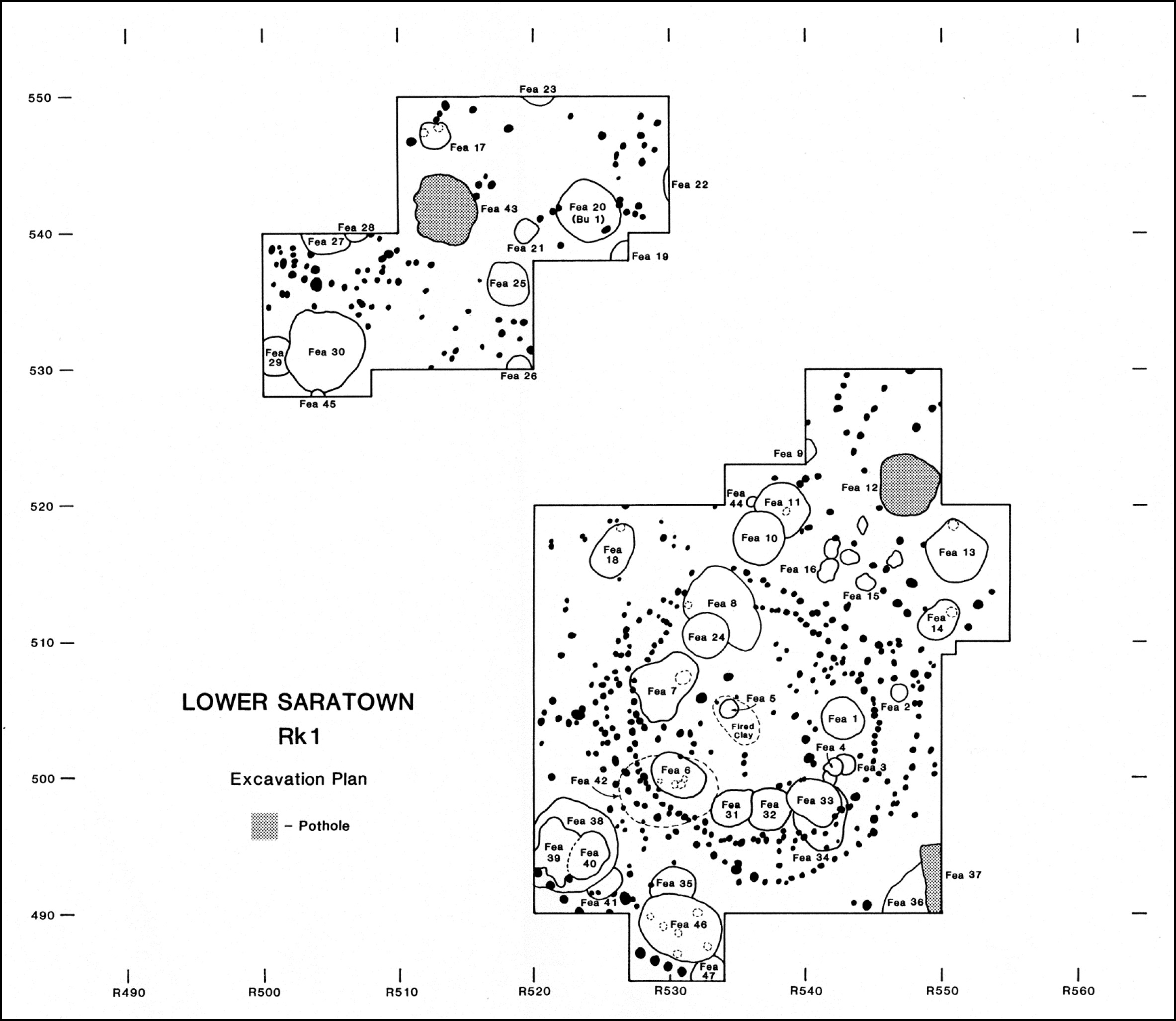
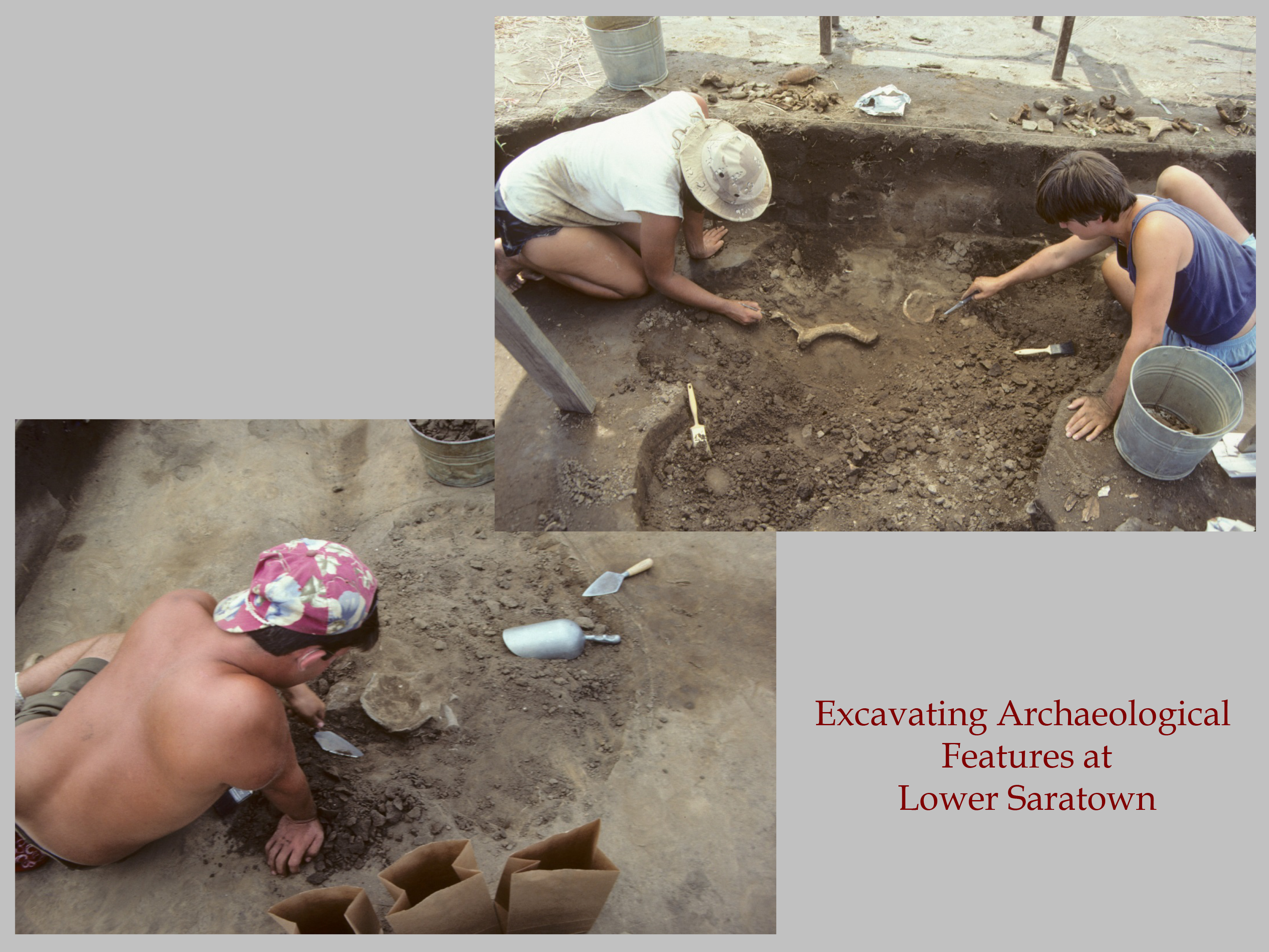
In November of 1987, archaeologists from UNC’s Research Laboratories of Archaeology attempted to re-locate Coe’s 1938 excavations by determining its position relative to a fence row mapped in 1938 and still located near the site. Once the approximate excavation area was identified, archaeologists used soil augers to systematically probe the area and find the edges of the earlier excavation. Since the field had been recently plowed, they also were able to map the site’s overal location by plotting the spatial distribution of artifacts visible on the ground surface. The following summer, UNC archaeologists excavated more than 1400 sq. ft. area just east of Coe’s excavation, and they located numerous pits and postholes that were rich with artifacts, many of which also had European glass trade beads. They also uncovered a burial and two concentric house structures, as well as a segment of a palisade line. The palisade, indicated by a straight line of large postholes at the southwest edge of the excavation, actually separated Coe’s 1938 excavation from the 1988 excavations. The palisade likely also constrained the distribution of refuse, including European trade artifacts, from the historic Middle Saratown phase (A.D. 1620-1670) village, such that evidence of the nearby historic village was not visible in the earlier excavation.
Research Questions
Because Lower Saratown has two components, it provides important information about two eras of Native history. During the last half of the Dan River phase (A.D. 1200-1450) we see a dramatic increase in settlement size and density. Most villages were located along the banks of the Smith and May Rivers in southern Virginia and the Dan River in North Carolina. Based on information drawn from a number of Dan River phase sites, villages were circular, about one to two acres in size, and surrounded by a defensive palisade, or stockade. Within the palisade would have been 15 to 20 households; the households were circular in shape with associated storage pits, burials, and hearths. Houses were located next to palisade walls and surrounded an open, central plaza where community activities took place. The increase in size of these communities seems to be associated with rapidly growing populations that were relying more extensively on maize cultivation. The construction of palisades to protect villages may have been related to increasing raids coming from the Iroquois to the north–a threat that was well-documented during the latter half of the 1600s.
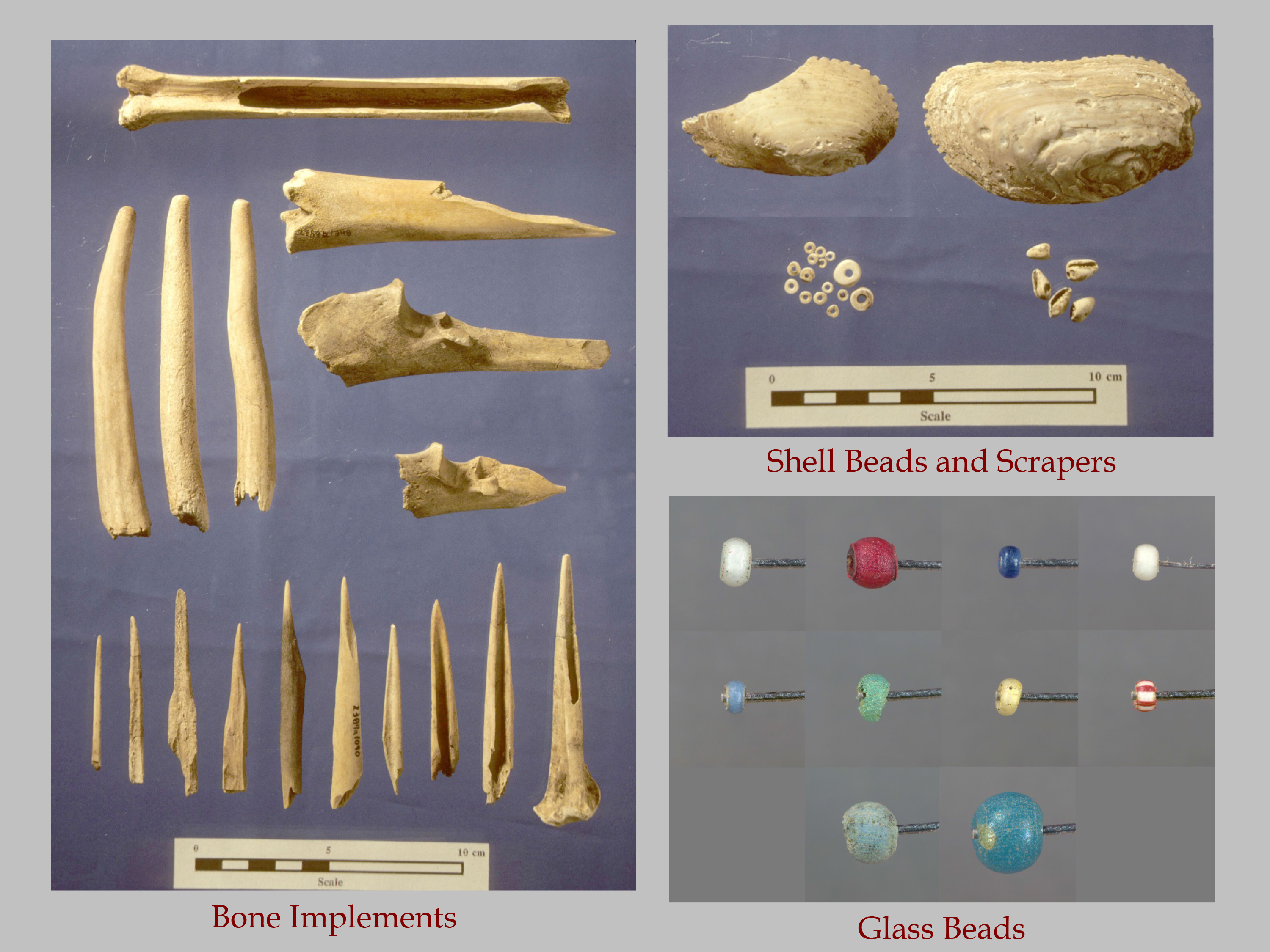
One of the most striking aspects of the Dan River phase are the many ornaments and tools made from bone, shell, and clay. On sites from this phase we find numerous awls, pins, needles, fish hooks, beamers, gouges, antler flakers, antler picks, turtle carapace bowls and cups, and a variety of beads. The edges of freshwater mussel shells were serrated and used as scrapers to thin the walls of pottery vessels. Marine whelk was carved and ground into long columella beads, shorter barrel and disk beads, gorgets, and pendants. And in addition to being made into pots, clay was also made into cups, spoons, dippers, beads, and smoking pipes. Pots are often highly decorated with notched lips and incised or punctated lines around the vessel rim or neck. Overall, the material culture of Dan River people displays a remarkable breadth of creativity and artisanship.
At the Lower Saratown site, four features were excavated that date to the Dan River phase occupation. Two features (Features 14 and 18) appear to be natural depressions in the ground that filled with soil during the village occupation. Feature 32 was a shallow basin with an unknown use that was later filled in, while Feature 41 was a circular storage pit that was rapidly filled once it was no longer needed for storage. Given the small number of Dan River phase features, there is not a lot of evidence about diet. However, what was recovered indicates that people consumed primarily mammals (rabbit, squirrel, raccoon, and deer), along with some turkey, reptiles (mud turtle, box turtle, and possibly snakes), and fish (gar and suckers). Plant remains included a high proportion of maize and hickory, along with grape, acorn, walnut, and hazelnut. With an increased sample of material and better preservation, there would presumably be a wider range of plants and animals represented.
The Middle Saratown phase (A.D. 1620-1670) marks the first arrival of European trade goods into the northern Piedmont. Settlements of this time period are similar to those of the preceding Early Saratown and Dan River phases. People continued to live in large stockaded villages, but there is some evidence that the major northern tributaries of the Dan River–the Smith and Mayo rivers–were largely abandoned by this time as the Sara population became more concentrated at the Lower Saratown and Upper Saratown localities. While we see evidence of European interaction with the introduction of glass beads and other brass ornaments, that interaction doesn’t appear to have changed much else in the lives of the Sara Indians.
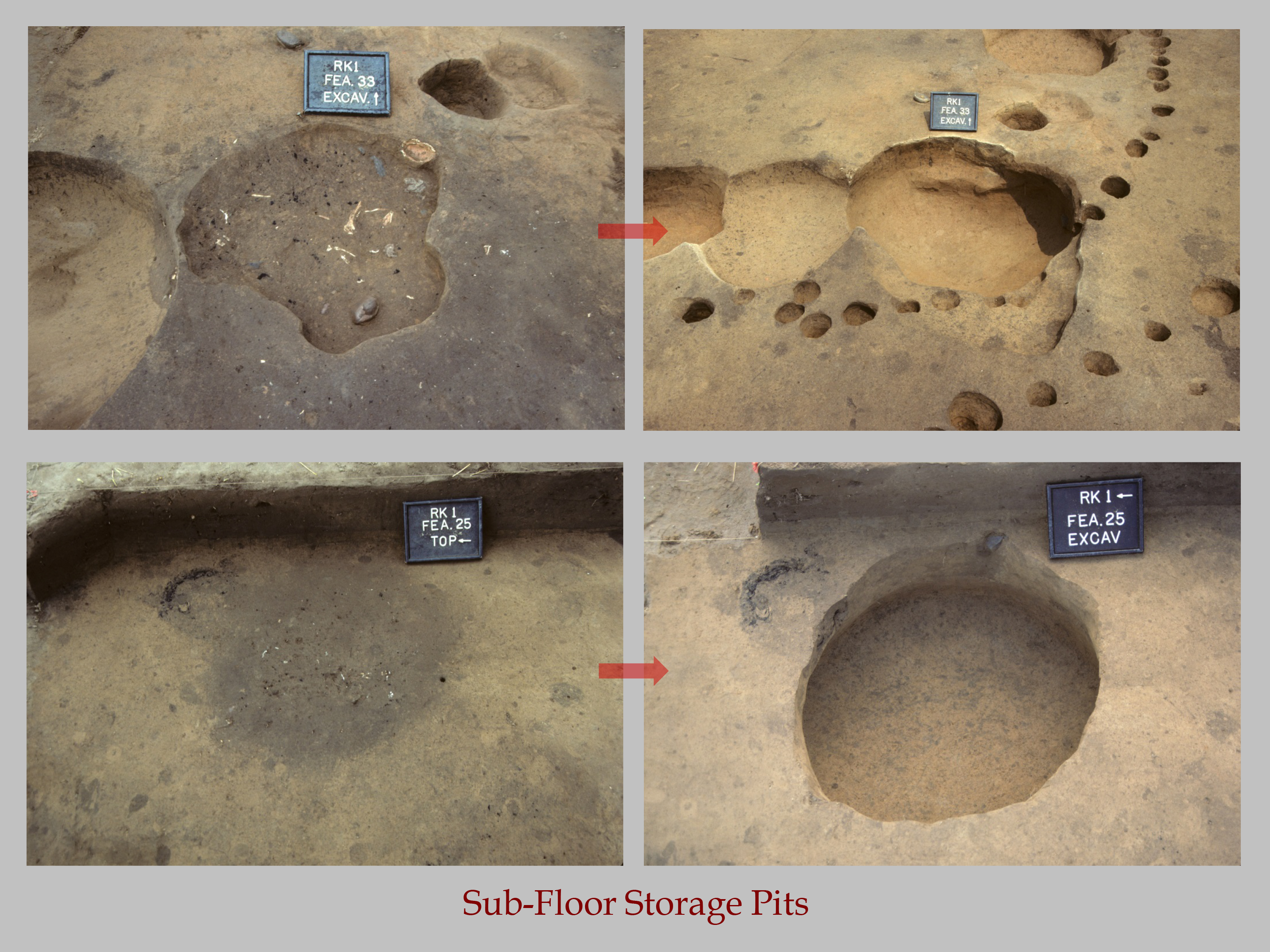
During excavations of the Sara village at Lower Saratown, three types of pit features were found. The first were storage pits, which were roughly circular in shape and over a foot deep below the base of plowed soil. These had straight sides with flat bottoms. After they were abandoned as storage facilities, they were quickly filled with refuse. The second type were pits interpreted as food preparation facilities, meaning ovens or roasting pits that were large, shallow, and oval in shape. Based on similarities with other sites, these cooking features are believed to be associated with village feasting activities, possibly linked with seasonal celebrations. Once the holes were dug, they were probably lined with vegetable materials and filled with meat, fish, and fowl. The food would have been covered over and a fire built on top, the same way that a pit barbecue is done today. After the cooking was done, the food was taken out, eaten, and then the leftover refuse was probably thrown back into the pit. The third feature type were smudge pits. These pits were small and conical in shape, and were filled with wood charcoal or burned corncobs. They were probably used to smoke and process animal hides, or to smudge the interiors of pottery vessels.

Due to the larger sample of pit features and midden contexts from the Middle Saratown phase, we have more food remains from which to infer information about people’s diets. Deer dominated the assemblage, the majority of which were either very young or very old. Annie Holm suggests this pattern is indicative of the use of stalking as a hunting strategy, rather than drives or surrounds. A small proportion of the mammalian assemblage consisted of raccoon, squirrel, opossums, bear, beaver, gray fox, striped skunk, mountain lion, and bobcat. As with the Dan River phase faunal assemblage, birds were much less important; the primary type of bird identified was turkey, along with some lesser scaup, yellow-shafted flicker, passenger pigeon, and cardinal. The most important reptiles were box turtle and mud turtle, along with small amounts of snapping turtle, musk turtle, slider, and soft-shelled turtle. Fish consisted of basses, sunfishes, white shad, redhorse, white sucker, gar, freshwater eel, catfish, and bowfin, all of which would have been readily available in nearby Dan River. A large amount of carbonized plant remains was analyzed as well. The most abundant cultivated plant was maize, although common bean and squash rind also were recovered. The most common nuts were hickory and acorn, while chestnut, walnut, and hazelnut were also identified. Lastly, fruits found in contexts dating to the Middle Saratown phase included maypops, persimmon, grape, and raspberry.
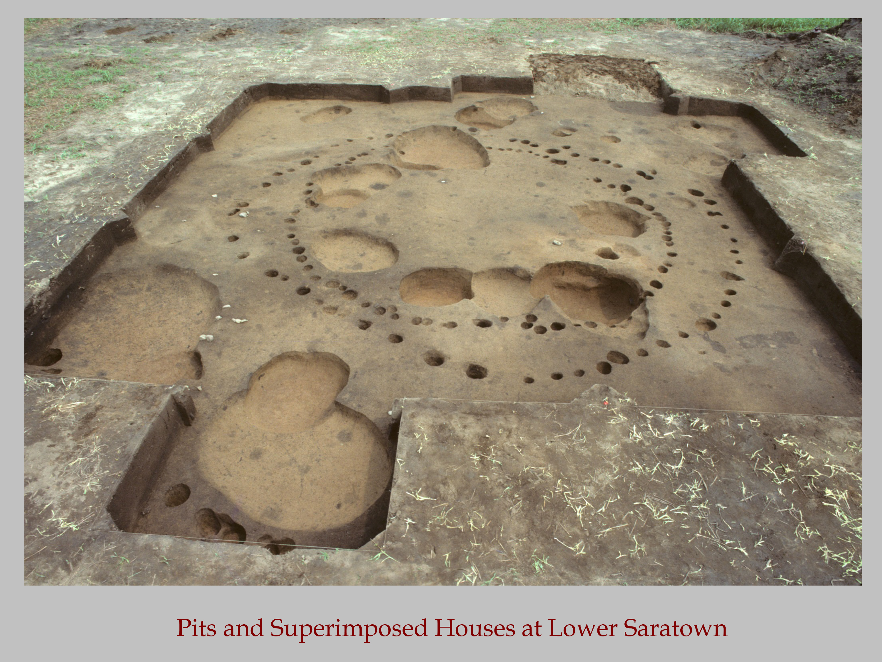
In addition to the pit features, postholes representing two houses were excavated that can be attributed to the Middle Saratown phase. Both structures–designated Structures 1 and 2–were located inside the palisade line and appear to represent two construction phases of the same dwelling. Structure 1 was oval in shape with tightly-spaced postholes. It was roughly 16 x 19 ft. in size, for a total roofed area of a little over 200 sq. ft. There may have been a hearth in the middle of the house, although it is unclear which house the hearth was associated with. Structure 2 was also oval in shape but was considerably larger than Structure 1, measuring 25 x 17.5 ft, for a total area of 320 sq. ft. The postholes indicate that the saplings used to build this house were roughly the same size as those used to build Structure 1, but they were not spaced as close together.
Because the posts of the two houses do not overlap, archaeologists are not positive which house came first. However, Structure 1 appears to have been fixed and rebuilt more than Structure 2, suggesting it was used for a longer period of time. This also suggests that Structure 1 may be the older of the two houses. Given the size of the houses, we can estimate that between 4-8 people lived in them at any time. Because there are no postholes to indicate internal supports, the houses were probably built like a wigwam. Saplings or small trees would have been stripped of their branches to make posts. The posts were then set in the ground and the tops were pulled together and tied to make a frame. Archaeologists did not find large amounts of daub (i.e., fired clay with preserved stick impressions) associated with either structure. The lack of daub suggests that the frame likely was covered with bark, hides, or other perishable materials instead of clay or plaster.
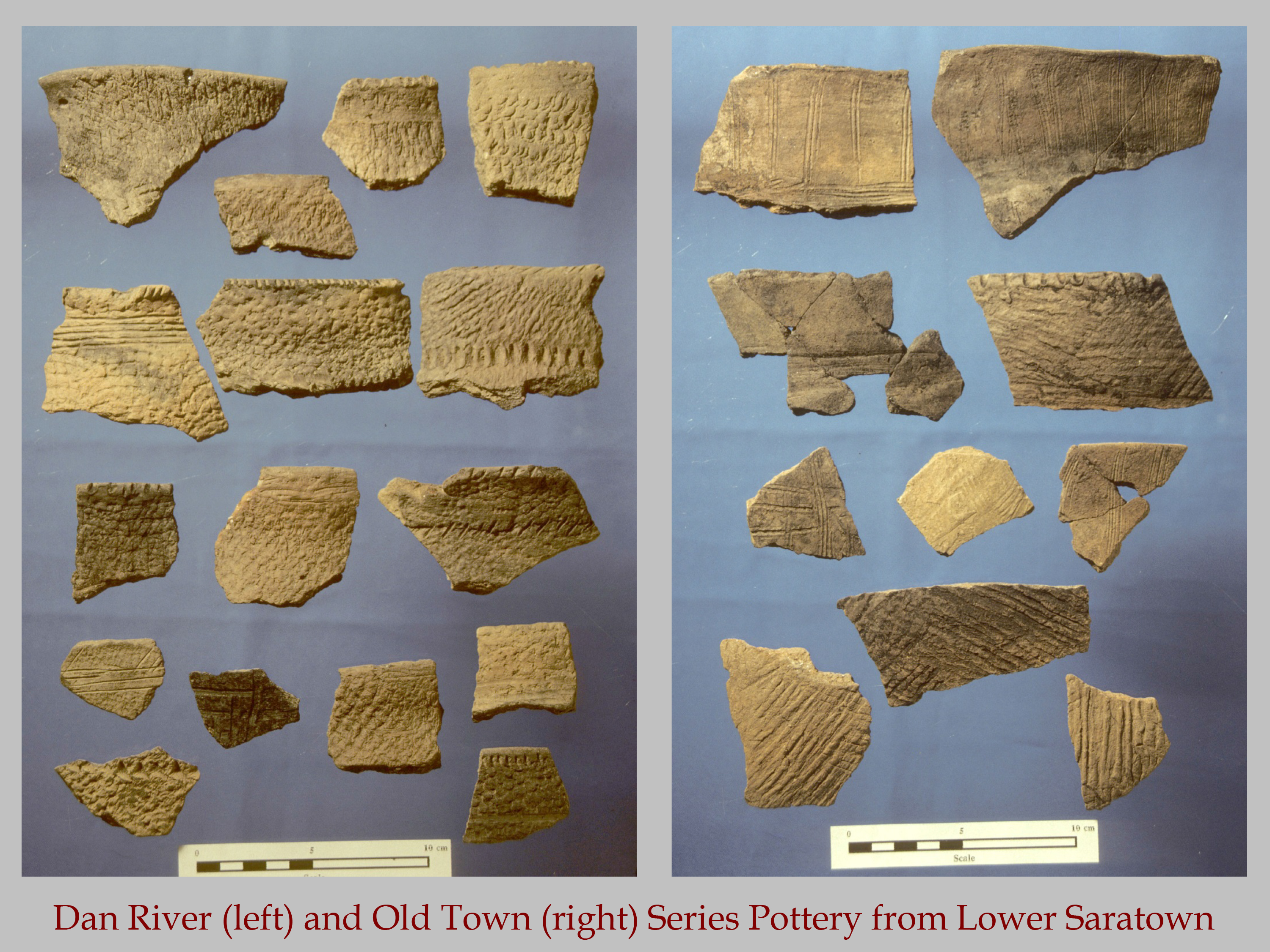
Pottery during the Middle Saratown phase resembles pottery that has also been found at the Hairston site, roughly 30 miles upstream at the Upper Saratown locality. Most sherds have either smoothed or polished exteriors, while many others were net-impressed. Smaller amounts of pottery had other surface treatments, including cob-impressing (created by rolling a dried corncob over the wet vessel exterior before firing) and various designs made by stamping the outside vessel surface with a carved wooden paddle (called simple stamping, check stamping, and complicated stamping, depending on the composition of the carved-paddle design).
In terms of stone tools, people living at Lower Saratownfrequently made small triangular arrow points and bifacial drills, as well as scavenging Archaic spear points from earlier settlements and reusing them. Other types of stone tools included chipped hoes, manos and milling stones, celts, hammerstones, and large cobble choppers. The bone and shell-working traditions that were seen in the earlier Dan River phase continued into the Middle Saratown phase.
Sources
Ward, Trawick H., and R. P. Stephen Davis, Jr.
1993 • Indian Communities on the North Carolina Piedmont A.D. 1000 to 1700. Monograph No.2, Research Laboratories of Anthropology, The University of North Carolina at Chapel Hill.
Ward, Trawick H., and R. P. Stephen Davis, Jr.
1999 • Time Before History: The Archaeology of North Carolina. University of North Carolina Press, Chapel Hill.