
Lowder’s Ferry (Stanly County)
Sometimes sites that don’t have a lot written about them can still be some of our most important sites. Lowder’s Ferry (31ST7) is one of these sites; while there is not much written material about it, it has a place of importance in North Carolina archaeology as one of the first deeply stratified sites to be dug (along with Hardaway and Doerschuk). Lowder’s Ferry is a buried site located along the alluvial terraces that flank the lower Yadkin River. It is located on the west bank of the Yadkin, across from the Yadkin’s confluence with the Uwharrie River. The site was originally dug by Joffre Coe and Paul Strieff in 1948.
History of Excavations
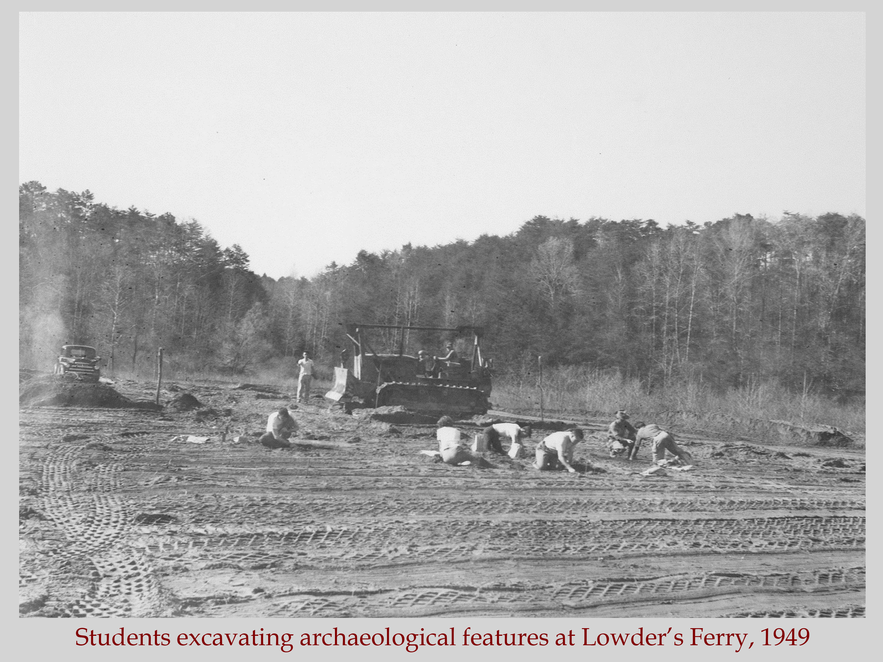
Towards the end of 1948, Coe was in the process of putting together a program of archaeology in the North Carolina Piedmont, based on funds from the North Carolina Division of State Parks. One of the first sites to be excavated as part of this program was Lowder’s Ferry, located within newly-created Morrow Mountain State Park. Coe assigned Paul Strieff the job of going back through information about known sites in the Uwharrie area in order to identify which ones might contain stratified archaeological deposits. Lowder’s Ferry was the first site where Strieff found evidence for such stratified deposits. In March of 1949, grading began at the site for construction of a parking lot next to a new boat ramp. This activity exposed the tops of five Late Woodland burials and several associated pits containing prehistoric pottery and other refuse. Work was halted while six UNC students conducted a two-day salvage excavation at the site.

Lowder’s Ferry was found to be a very rich site with substantial Archaic-period deposits, so the parking lot construction was delayed further and the archaeology continued. Excavations focused on the Archaic levels of the site, with UNC student James Wood supervising the work. Before Wood left to resume classes in August, five trenches had been excavated in the graded area. In September of 1949, excavations resumed under the direction of Barton Wright, an archaeologist stationed at nearby Town Creek Indian Mound. Trenches were continued, several small test pits were excavated, and a large block excavation was opened next to Wood’s first trench. By the time excavations were comcluded in December, a Middle Archaic Guilford level was identified that could be separated stratigraphically from an overlying Late Archaic Savannah River level. Today, the site is mostly under a parking lot that leads to a boat ramp at the upper end of Lake Tillery.
Research Questions
The thick, organically stained soil at Lowder’s Ferry, Doerschuk, and Gaston indicate that occupation was more intense during the Late Archaic period than during the Early and Middle Archaic periods. This just means that people were spending more time at these camps, causing them to accumulate the trash that enriched the soil. Small, circular pit-hearths that were lined with stones also suggest more permanent stays that are not reflected in the earlier occupations. Although we don’t yet have food remains from such early sites in the North Carolina Piedmont, we can still infer diet from indirect evidence about where the site was located. Lowder’s Ferry is located along a major river, suggesting that fish, turtles, and migratory waterfowl would have been important foods, probably along with freshwater mussels.
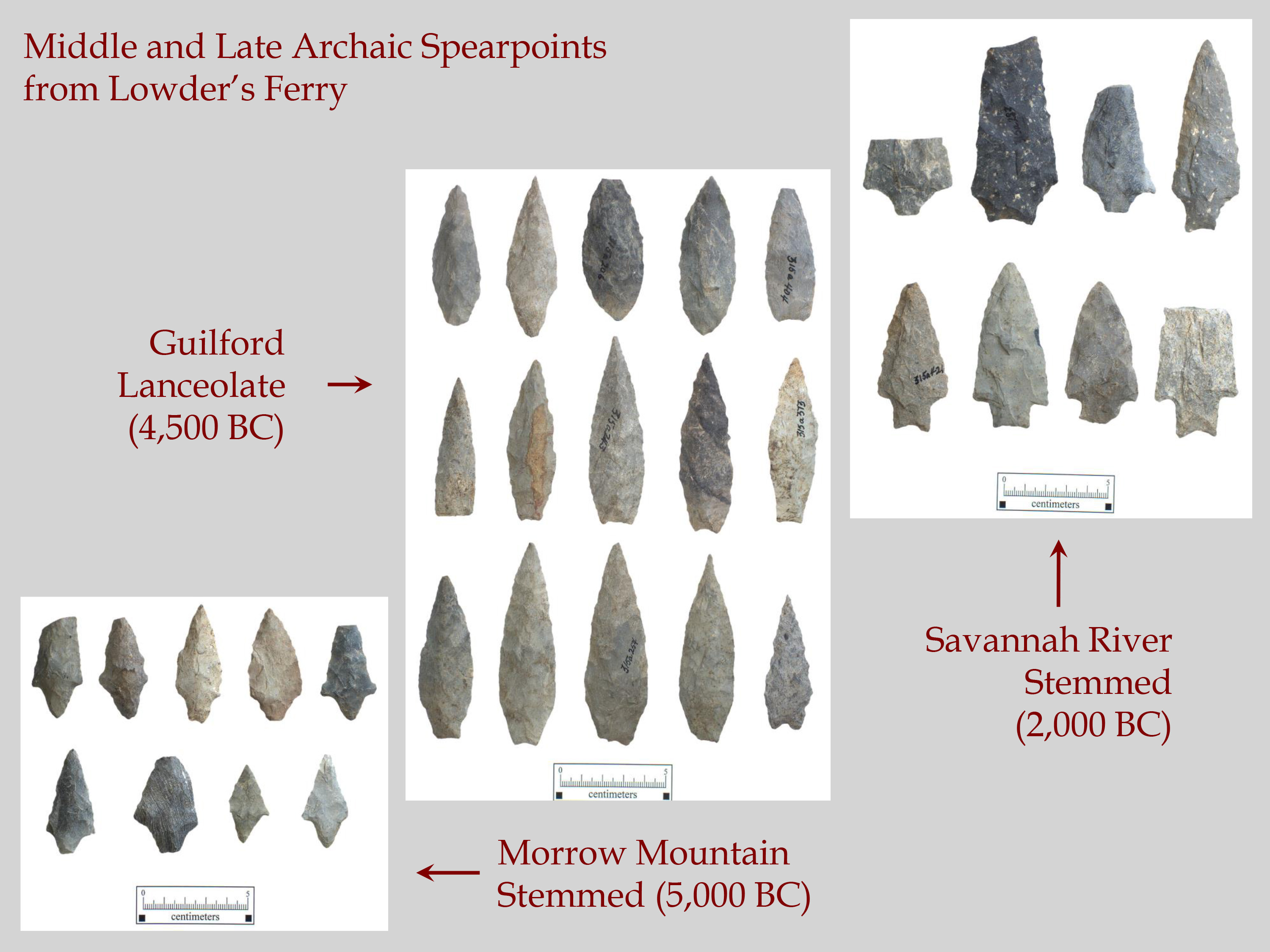
While Lowder’s Ferry is important for the information it provides about prehistoric peoples in general, it might be even more important for its soil stratigraphy. You will recall from the initial description of the site that Lowder’s Ferry is one of three deeply stratified sites (along with Hardaway and Doerschuk) that Joffre Coe used to define and construct a sequence of Archaic projectile point types. Described in more detail for the Doerschuk site, Coe theorized that the Middle Archaic Stanly, Morrow Mountain, and Guilford point traditions all represented different groups of people. However, when Carmen Drye went back through the material from Lowder’s Ferry, she found inconsistencies in Coe’s reporting. By going back through field notes and artifact bags, Drye was able to reconstruct the stratigraphic sequence at Lowder’s Ferry. She was able to identify both a Middle Archaic Guilford occupation (roughly 4000 to 3000 B.C.) that was three feet below the surface, as well as an uncontaminated and undisturbed red soil layer that also dated to the Archaic period. In the red soil layer, Drye documented the co-occurence of Morrow Mountain II, Guilford, and Savannah River points, indicating they likely were left behind by the same people. She also found a number of transitional spear point forms that support the idea that Morrow Mountain II, Guilford, and Savannah River point types are products of a single stone-tool tradition that spanned the Middle and Late Archaic periods.
Sources
Coe, Joffre L.
1964 • The Formative Cultures of the Carolina Piedmont. Transactions of the American Philosophical Society, n.s., 54, pt. 5, Philadelphia.
Drye, Carmen Morgan
1998 • An Analysis and Interpretation of the Archaic Projectile Point Sequence from Lowder’s Ferry, Stanly County, North Carolina. North Carolina Archaeology 47:34-65.
Ward, Trawick H., and R. P. Stephen Davis, Jr.
1999 • Time Before History: The Archaeology of North Carolina. University of North Carolina Press, Chapel Hill.